Geolokalisieren

Topografische Karte A Rañoá

Klicken Sie auf die Karte, um die Höhe anzuzeigen.

Über diese Karte
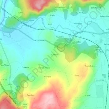
Name: Topografische Karte A Rañoá, Höhe, Relief.

Ort: A Rañoá, Vilar, Sarria, Lugo, Galicia, 27617, España (42.80957 -7.43495 42.84957 -7.39495)

Durchschnittliche Höhe: 429 m

Minimale Höhe: 374 m

Maximale Höhe: 543 m

Andere topografische Karten

Klicken Sie auf eine Karte, um ihre Topografie, ihre Höhe und ihr Relief anzuzeigen.
Chorente

España > Galicia > Sarria > Sarria

Durchschnittliche Höhe: 626 m

Vilamaior

España > Galicia > Sarria > Sarria

Durchschnittliche Höhe: 623 m

Santo André de Paradela

España > Galicia > Sarria > Sarria

Durchschnittliche Höhe: 578 m

Fontao

España > Galicia > Sarria > Sarria

Durchschnittliche Höhe: 460 m

Barbadelo

España > Galicia > Sarria > Sarria

Durchschnittliche Höhe: 576 m

Ortoá

España > Galicia > Sarria > Sarria

Durchschnittliche Höhe: 614 m

Louseiro

España > Galicia > Sarria > Sarria

Durchschnittliche Höhe: 507 m

Rüsten Sie sich für Ihr nächstes Abenteuer:

🎒Trekkingrucksack 70L - Großer Rucksack für Mehrtagestouren mit Kartenfach
🧦Thermo Wandersocken - Komfortable Socken für lange Touren
🛋️Leichte Campingstühle - Faltbarer Komfort für die Rast nach der Wanderung
📍GPS Wanderuhr - Smartwatch mit Navigation & Kartenfeatures
🦶Blasenpflaster-Sets - Schnelle Hilfe bei Druckstellen und Blasen

Als Amazon-Partner erhält diese Website eine Provision für qualifizierte Käufe, ohne zusätzliche Kosten für Sie.