
Topografische Karte Moricone
Interaktive Karte
Klicken Sie auf die Karte, um die Höhe anzuzeigen.
Über diese Karte
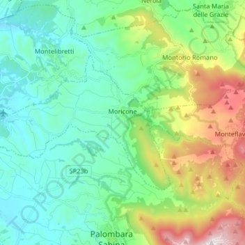
Name: Topografische Karte Moricone, Höhe, Relief.
Ort: Moricone, Roma Capitale, Lazio, Italië (42.08603 12.66660 42.13924 12.79698)
Durchschnittliche Höhe: 360 m
Minimale Höhe: 68 m
Maximale Höhe: 1.170 m
Andere topografische Karten
Klicken Sie auf eine Karte, um ihre Topografie, ihre Höhe und ihr Relief anzuzeigen.
Sant'Oreste
Italië > Lazio > Roma Capitale
Sant'Oreste, Roma Capitale, Lazio, Italië
Durchschnittliche Höhe: 170 m
Engelenburcht
Italië > Lazio > Roma Capitale > Rome
Engelenburcht, Lungotevere Castello, Borgo, Municipio Roma I, Rome, Roma Capitale, Lazio, 00193, Italië
Durchschnittliche Höhe: 36 m
Lago di Traiano
Italië > Lazio > Roma Capitale > Fiumicino > Episcopio di Porto
Lago di Traiano, Episcopio di Porto, Fiumicino, Roma Capitale, Lazio, Italië
Durchschnittliche Höhe: 3 m
Rome
Italië > Lazio > Roma Capitale > Rome
Rome, Roma Capitale, Lazio, 00100, Italië
Durchschnittliche Höhe: 78 m