
Topografische Karte Huanchaco
Interaktive Karte
Klicken Sie auf die Karte, um die Höhe anzuzeigen.
Über diese Karte
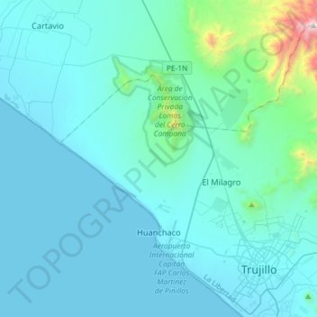
Name: Topografische Karte Huanchaco, Höhe, Relief.
Ort: Huanchaco, Trujillo, La Libertad, Peru (-8.13313 -79.21050 -7.89226 -78.92180)
Durchschnittliche Höhe: 174 m
Minimale Höhe: -1 m
Maximale Höhe: 2.093 m
Andere topografische Karten
Klicken Sie auf eine Karte, um ihre Topografie, ihre Höhe und ihr Relief anzuzeigen.
Brasil
Peru > La Libertad > Colpa
Brasil, Colpa, Sayapullo, Gran Chimú, La Libertad, Peru
Durchschnittliche Höhe: 1.915 m
El Zaile
Peru > La Libertad > Santiago de Chuco > El Zaile
El Zaile, Santiago de Chuco, La Libertad, Peru
Durchschnittliche Höhe: 3.420 m
Cascas
Peru > La Libertad > Cascas > Cascas
Cascas, Gran Chimú, La Libertad, Peru
Durchschnittliche Höhe: 1.627 m
La Cuesta
Peru > La Libertad > La Cuesta
La Cuesta, Otuzco, La Libertad, Peru
Durchschnittliche Höhe: 2.746 m
Nuevo Chao
Peru > La Libertad > Nuevo Chao
Nuevo Chao, Chao, Virú, La Libertad, Peru
Durchschnittliche Höhe: 148 m
La Esperanza
La Esperanza, Trujillo, La Libertad, Peru
Durchschnittliche Höhe: 115 m
Chepén
Peru > La Libertad > Pacanga
Chepén, Pacanga, Chepén, La Libertad, Peru
Durchschnittliche Höhe: 115 m