
Topografische Karte Palvelicham
Interaktive Karte
Klicken Sie auf die Karte, um die Höhe anzuzeigen.
Über diese Karte
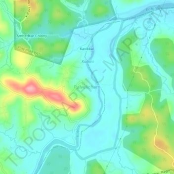
Name: Topografische Karte Palvelicham, Höhe, Relief.
Ort: Palvelicham, Mananthavady, Wayanad District, Kerala, India (11.80197 76.06786 11.84197 76.10786)
Durchschnittliche Höhe: 735 m
Minimale Höhe: 704 m
Maximale Höhe: 825 m
Andere topografische Karten
Klicken Sie auf eine Karte, um ihre Topografie, ihre Höhe und ihr Relief anzuzeigen.
Karimala
India > Kerala > Mananthavady
Karimala, Mananthavady, Wayanad District, Kerala, India
Durchschnittliche Höhe: 1.324 m
Dwaraka
India > Kerala > Mananthavady
Dwaraka, Mananthavady, Wayanad District, Kerala, 670732, India
Durchschnittliche Höhe: 746 m
Thirunelli
India > Kerala > Mananthavady
Thirunelli, Mananthavady, Wayanad District, Kerala, India
Durchschnittliche Höhe: 969 m
Anjukunnu
India > Kerala > Mananthavady
Anjukunnu, Mananthavady, Wayanad, Kerala, 670732, India
Durchschnittliche Höhe: 745 m
Kattimoola
India > Kerala > Mananthavady
Kattimoola, Mananthavady, Wayanad, Kerala, 670644, India
Durchschnittliche Höhe: 753 m
nedumblassery colony
India > Kerala > Mananthavady
nedumblassery colony, Mananthavady, Wayanad District, Kerala, 670731, India
Durchschnittliche Höhe: 758 m
Panamaram
India > Kerala > Mananthavady > Panamaram
Panamaram, Mananthavady, Wayanad, Kerala, 670721, India
Durchschnittliche Höhe: 736 m
Thavinhal
India > Kerala > Mananthavady > Boy's Town
Thavinhal, Boy's Town, Mananthavady, Wayanad, Kerala, India
Durchschnittliche Höhe: 690 m