
Topografische Karte Padul
Interaktive Karte
Klicken Sie auf die Karte, um die Höhe anzuzeigen.
Padul
El Padul is a municipality of south-eastern Spain, in the province of Granada, within the comarca of el Valle de Lecrín. The population on 2008 was 8.440 inhabitants. This town is situated 13 km at the south of the city of Granada. Its altitude is 744 meters above the sea level.
Über diese Karte
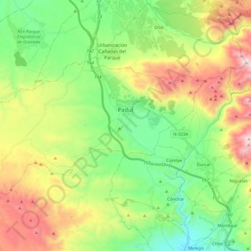
Name: Topografische Karte Padul, Höhe, Relief.
Durchschnittliche Höhe: 964 m
Minimale Höhe: 508 m
Maximale Höhe: 1.754 m
Andere topografische Karten
Klicken Sie auf eine Karte, um ihre Topografie, ihre Höhe und ihr Relief anzuzeigen.
Cortijo de la eña
Spain > Andalusia > Comarca del Valle de Lecrín > Lecrín
Durchschnittliche Höhe: 1.158 m