
Topografische Karte Sarez Lake
Interaktive Karte
Klicken Sie auf die Karte, um die Höhe anzuzeigen.
Über diese Karte
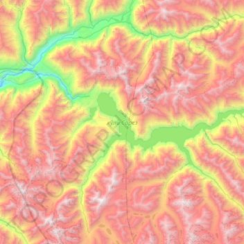
Name: Topografische Karte Sarez Lake, Höhe, Relief.
Durchschnittliche Höhe: 4.302 m
Minimale Höhe: 2.565 m
Maximale Höhe: 5.886 m
Sarez Lake (Tajik: Сарез кӯл, romanized: Sarez Kūl) is a lake in Rushon District of Gorno-Badakhshan province, Tajikistan. Length about 75.8 kilometres (47.1 mi), depth few hundred meters, water surface elevation about 3,263 metres (10,705 ft) above sea level and volume of water is more than 16 cubic kilometres (3.8 cu mi). The mountains around rise more than 2,300 metres (7,500 ft) above the lake level.
Andere topografische Karten
Klicken Sie auf eine Karte, um ihre Topografie, ihre Höhe und ihr Relief anzuzeigen.
Independence Peak
Tajikistan > Gorno-Badakhshan Autonomous Region > Rushon District
Independence Peak, Rushon District, Gorno-Badakhshan Autonomous Region, Tajikistan
Durchschnittliche Höhe: 6.373 m
Rushon
Tajikistan > Gorno-Badakhshan Autonomous Region > Rushon District
Rushon, Rushon District, Gorno-Badakhshan Autonomous Region, Tajikistan
Durchschnittliche Höhe: 2.613 m