
Topografische Karte Alpago
Interaktive Karte
Klicken Sie auf die Karte, um die Höhe anzuzeigen.
Über diese Karte
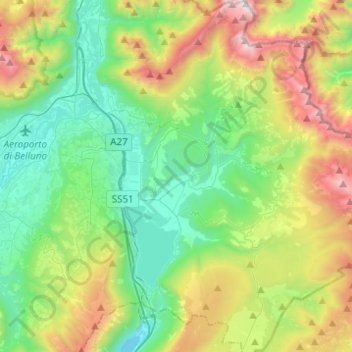
Name: Topografische Karte Alpago, Höhe, Relief.
Ort: Alpago, Belluno, Veneto, Italië (46.05860 12.30215 46.22903 12.41812)
Durchschnittliche Höhe: 947 m
Minimale Höhe: 268 m
Maximale Höhe: 2.438 m
Andere topografische Karten
Klicken Sie auf eine Karte, um ihre Topografie, ihre Höhe und ihr Relief anzuzeigen.
Santa Giustina
Santa Giustina, Belluno, Veneto, 32035, Italië
Durchschnittliche Höhe: 579 m
Fiames
Italië > Veneto > Belluno > Cortina d'Ampezzo
Fiames, Cortina d'Ampezzo, Belluno, Veneto, 32043, Italië
Durchschnittliche Höhe: 1.667 m
Cencenighe Agordino
Cencenighe Agordino, Belluno, Veneto, Italië
Durchschnittliche Höhe: 1.361 m
Monte Cristallo
Italië > Veneto > Belluno > Cortina d'Ampezzo
Monte Cristallo, Cortina d'Ampezzo, Belluno, Veneto, Italië
Durchschnittliche Höhe: 2.465 m
Passo Giau
Italië > Veneto > Belluno > Colle Santa Lucia
Passo Giau, SP638, Colle Santa Lucia, Belluno, Veneto, Italië
Durchschnittliche Höhe: 2.125 m
Rocca Pietore
Rocca Pietore, Belluno, Veneto, Italië
Durchschnittliche Höhe: 1.691 m
Malga Ciapela
Italië > Veneto > Belluno > Rocca Pietore > Malga Ciapela
Malga Ciapela, Rocca Pietore, Belluno, Veneto, 32020, Italië
Durchschnittliche Höhe: 1.866 m
Cortina d'Ampezzo
Italië > Veneto > Belluno > Cortina d'Ampezzo > Cortina d'Ampezzo
Cortina d'Ampezzo, Belluno, Veneto, 32043, Italië
Durchschnittliche Höhe: 1.649 m
Cortina d'Ampezzo
Cortina d'Ampezzo, Belluno, Veneto, 32043, Italië
Durchschnittliche Höhe: 1.974 m