
Topografische Karte Langley
Interaktive Karte
Klicken Sie auf die Karte, um die Höhe anzuzeigen.
Über diese Karte
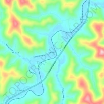
Name: Topografische Karte Langley, Höhe, Relief.
Ort: Langley, Floyd County, Kentucky, 41645, United States (37.51177 -82.81072 37.55177 -82.77072)
Durchschnittliche Höhe: 277 m
Minimale Höhe: 193 m
Maximale Höhe: 473 m
Andere topografische Karten
Klicken Sie auf eine Karte, um ihre Topografie, ihre Höhe und ihr Relief anzuzeigen.
Beaver
United States > Kentucky > Floyd County
Beaver, Floyd County, Kentucky, 41660, United States
Durchschnittliche Höhe: 443 m
Drift
United States > Kentucky > Floyd County
Drift, Floyd County, Kentucky, 41651, United States
Durchschnittliche Höhe: 312 m
Melvin
United States > Kentucky > Floyd County
Melvin, Floyd County, Kentucky, 41650, United States
Durchschnittliche Höhe: 430 m
David
United States > Kentucky > Floyd County
David, Floyd County, Kentucky, 41616, United States
Durchschnittliche Höhe: 326 m
Stanville
United States > Kentucky > Floyd County
Stanville, Floyd County, Kentucky, 41663, United States
Durchschnittliche Höhe: 281 m
Wheelwright
United States > Kentucky > Floyd County
Wheelwright, Floyd County, Kentucky, 41669, United States
Durchschnittliche Höhe: 445 m
Dwale
United States > Kentucky > Floyd County
Dwale, Floyd County, Kentucky, 41621, United States
Durchschnittliche Höhe: 270 m
Bypro
United States > Kentucky > Floyd County
Bypro, Floyd County, Kentucky, 41612, United States
Durchschnittliche Höhe: 399 m
Dana
United States > Kentucky > Floyd County
Dana, Floyd County, Kentucky, 41615, United States
Durchschnittliche Höhe: 322 m
Hi Hat
United States > Kentucky > Floyd County
Hi Hat, Floyd County, Kentucky, 41636, United States
Durchschnittliche Höhe: 383 m
Ivel
United States > Kentucky > Floyd County
Ivel, Floyd County, Kentucky, 41603, United States
Durchschnittliche Höhe: 282 m
Teaberry
United States > Kentucky > Floyd County
Teaberry, Floyd County, Kentucky, 41660, United States
Durchschnittliche Höhe: 395 m
Printer
United States > Kentucky > Floyd County
Printer, Floyd County, Kentucky, 41655, United States
Durchschnittliche Höhe: 296 m
Martin
United States > Kentucky > Floyd County
Martin, Floyd County, Kentucky, United States
Durchschnittliche Höhe: 269 m
Betsy Layne
United States > Kentucky > Floyd County
Betsy Layne, Floyd County, Kentucky, 41605, United States
Durchschnittliche Höhe: 270 m
Allen
United States > Kentucky > Floyd County
Allen, Floyd County, Kentucky, United States
Durchschnittliche Höhe: 261 m
Banner
United States > Kentucky > Floyd County
Banner, Floyd County, Kentucky, 41603, United States
Durchschnittliche Höhe: 278 m
Garrett
United States > Kentucky > Floyd County
Garrett, Floyd County, Kentucky, 41630, United States
Durchschnittliche Höhe: 292 m
Hueysville
United States > Kentucky > Floyd County
Hueysville, Floyd County, Kentucky, 41630, United States
Durchschnittliche Höhe: 288 m
McDowell
United States > Kentucky > Floyd County
McDowell, Floyd County, Kentucky, 41647, United States
Durchschnittliche Höhe: 324 m
Weeksbury
United States > Kentucky > Floyd County
Weeksbury, Floyd County, Kentucky, 41669, United States
Durchschnittliche Höhe: 487 m
Blue River
United States > Kentucky > Floyd County
Blue River, Floyd County, Kentucky, 41607, United States
Durchschnittliche Höhe: 277 m
Ligon
United States > Kentucky > Floyd County
Ligon, Floyd County, Kentucky, 41604, United States
Durchschnittliche Höhe: 451 m
Welco Station
United States > Kentucky > Floyd County
Welco Station, Floyd County, Kentucky, 41630, United States
Durchschnittliche Höhe: 289 m
Eastern
United States > Kentucky > Floyd County
Eastern, Floyd County, Kentucky, 41622, United States
Durchschnittliche Höhe: 274 m
Dema
United States > Kentucky > Floyd County
Dema, Floyd County, Kentucky, 41666, United States
Durchschnittliche Höhe: 355 m
Minnie
United States > Kentucky > Floyd County
Minnie, Floyd County, Kentucky, 41651, United States
Durchschnittliche Höhe: 316 m
Prestonsburg
United States > Kentucky > Floyd County > Prestonsburg > Prestonsburg
Prestonsburg, Floyd County, Kentucky, 41653, United States
Durchschnittliche Höhe: 274 m
Auxier
United States > Kentucky > Floyd County
Auxier, Floyd County, Kentucky, 41216, United States
Durchschnittliche Höhe: 244 m
Harold
United States > Kentucky > Floyd County
Harold, Floyd County, Kentucky, 41635, United States
Durchschnittliche Höhe: 268 m
Northern
United States > Kentucky > Floyd County
Northern, Floyd County, Kentucky, 41622, United States
Durchschnittliche Höhe: 285 m
Wayland
United States > Kentucky > Floyd County
Wayland, Floyd County, Kentucky, United States
Durchschnittliche Höhe: 323 m
Dewey Lake
United States > Kentucky > Floyd County > Prestonsburg
Dewey Lake, Prestonsburg, Floyd County, Kentucky, United States
Durchschnittliche Höhe: 273 m