
Spenden
Rüsten Sie sich für Ihr nächstes Abenteuer:
Als Amazon-Partner erhält diese Website eine Provision für qualifizierte Käufe, ohne zusätzliche Kosten für Sie.
Topografische Karte Mogra Khurd
Klicken Sie auf die Karte, um die Höhe anzuzeigen.
Spenden
Rüsten Sie sich für Ihr nächstes Abenteuer:
Als Amazon-Partner erhält diese Website eine Provision für qualifizierte Käufe, ohne zusätzliche Kosten für Sie.
Über diese Karte
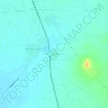
Name: Topografische Karte Mogra Khurd, Höhe, Relief.
Durchschnittliche Höhe: 199 m
Minimale Höhe: 193 m
Maximale Höhe: 228 m
Spenden
Rüsten Sie sich für Ihr nächstes Abenteuer:
Als Amazon-Partner erhält diese Website eine Provision für qualifizierte Käufe, ohne zusätzliche Kosten für Sie.
Andere topografische Karten
Klicken Sie auf eine Karte, um ihre Topografie, ihre Höhe und ihr Relief anzuzeigen.
Jalore
The district is bounded on the northwest by Balotra District, on the northeast by Pali District, on the southeast by Sirohi District, and by Banaskantha District of Gujarat state on the southwest. The total area of the district is 10,640 km2 (4,108 sq mi). The altitude is 268 m, latitude is 25.22 N and…
Durchschnittliche Höhe: 183 m
Karauli
The Chambal River forms the southeastern boundary of the district with the state of Madhya Pradesh, around 5 kilometres (3.1 mi) away from Mandrayal. Although most of Karauli district is composed of hills and valleys, there are no high mountains, with the highest having an elevation less than 450 metres (1,480…
Durchschnittliche Höhe: 263 m
Spenden
Rüsten Sie sich für Ihr nächstes Abenteuer:
Als Amazon-Partner erhält diese Website eine Provision für qualifizierte Käufe, ohne zusätzliche Kosten für Sie.
Spenden
Rüsten Sie sich für Ihr nächstes Abenteuer:
Als Amazon-Partner erhält diese Website eine Provision für qualifizierte Käufe, ohne zusätzliche Kosten für Sie.
Spenden
Rüsten Sie sich für Ihr nächstes Abenteuer:
Als Amazon-Partner erhält diese Website eine Provision für qualifizierte Käufe, ohne zusätzliche Kosten für Sie.
Spenden
Rüsten Sie sich für Ihr nächstes Abenteuer:
Als Amazon-Partner erhält diese Website eine Provision für qualifizierte Käufe, ohne zusätzliche Kosten für Sie.
Spenden
Rüsten Sie sich für Ihr nächstes Abenteuer:
Als Amazon-Partner erhält diese Website eine Provision für qualifizierte Käufe, ohne zusätzliche Kosten für Sie.
Pratapgarh
Pratapgarh is located at 24.03° N 74.78° E with an average elevation of 580 meters (1610 feet above mean sea level). It is said to be the second highest place (?) in Rajasthan after Mount Abu. Situated on the junction of the Aravali mountain ranges and the Malwa Plateau its unique location prominently…
Durchschnittliche Höhe: 390 m
Spenden
Rüsten Sie sich für Ihr nächstes Abenteuer:
Als Amazon-Partner erhält diese Website eine Provision für qualifizierte Käufe, ohne zusätzliche Kosten für Sie.
Spenden
Rüsten Sie sich für Ihr nächstes Abenteuer:
Als Amazon-Partner erhält diese Website eine Provision für qualifizierte Käufe, ohne zusätzliche Kosten für Sie.
Spenden
Rüsten Sie sich für Ihr nächstes Abenteuer:
Als Amazon-Partner erhält diese Website eine Provision für qualifizierte Käufe, ohne zusätzliche Kosten für Sie.
Spenden
Rüsten Sie sich für Ihr nächstes Abenteuer:
Als Amazon-Partner erhält diese Website eine Provision für qualifizierte Käufe, ohne zusätzliche Kosten für Sie.
Spenden
Rüsten Sie sich für Ihr nächstes Abenteuer:
Als Amazon-Partner erhält diese Website eine Provision für qualifizierte Käufe, ohne zusätzliche Kosten für Sie.
Sirohi
Sirohi District is broken up by hills and rocky ranges. The granite massif of Mount Abu divides the district into two portions, running from north-east to south-west. The south and south-east part of the district, which lies between Mount Abu and the main spine of the Aravallis, is mountainous and rugged, and…
Durchschnittliche Höhe: 351 m
Spenden
Rüsten Sie sich für Ihr nächstes Abenteuer:
Als Amazon-Partner erhält diese Website eine Provision für qualifizierte Käufe, ohne zusätzliche Kosten für Sie.
Spenden
Rüsten Sie sich für Ihr nächstes Abenteuer:
Als Amazon-Partner erhält diese Website eine Provision für qualifizierte Käufe, ohne zusätzliche Kosten für Sie.
Spenden
Rüsten Sie sich für Ihr nächstes Abenteuer:
Als Amazon-Partner erhält diese Website eine Provision für qualifizierte Käufe, ohne zusätzliche Kosten für Sie.
Spenden
Rüsten Sie sich für Ihr nächstes Abenteuer:
Als Amazon-Partner erhält diese Website eine Provision für qualifizierte Käufe, ohne zusätzliche Kosten für Sie.
Pokaran
India > Rajasthan > Pokaran Tehsil
Pokhran is located 112 km east of Jaisalmer city, 172 km northwest of Jodhpur and 225 km south of Bikaner by road. It lies on Jaisalmer to Jodhpur railway line. It is situated at 27°05′42″N 71°45′11″E / 27.095°N 71.753°E / 27.095; 71.753 and has an average elevation of 233 metres (764 feet).
Durchschnittliche Höhe: 229 m
Padampur
India > Rajasthan > Padampur Tehsil
Located in southwest of the Ganganagar district, the city has an average elevation of 165 metres (541 ft)
Durchschnittliche Höhe: 169 m
Pratapgarh
Pratapgarh is located at 24.03° N 74.78° E with an average elevation of 580 meters (1610 feet above mean sea level). It is said to be the second highest place (?) in Rajasthan after Mount Abu. Situated on the junction of the Aravali mountain ranges and the Malwa Plateau its unique location prominently…
Durchschnittliche Höhe: 390 m
Haldighati Park
India > Rajasthan > Sanganer Tehsil > Jaipur Municipal Corporation
Durchschnittliche Höhe: 372 m
Spenden
Rüsten Sie sich für Ihr nächstes Abenteuer:
Als Amazon-Partner erhält diese Website eine Provision für qualifizierte Käufe, ohne zusätzliche Kosten für Sie.
Spenden
Rüsten Sie sich für Ihr nächstes Abenteuer:
Als Amazon-Partner erhält diese Website eine Provision für qualifizierte Käufe, ohne zusätzliche Kosten für Sie.
Hindaun
India > Rajasthan > Hindaun Tehsil
Hindaun has an average elevation of 235 metres (771 ft). Its distance from the state capital of Jaipur is around 150 km.
Durchschnittliche Höhe: 230 m
Spenden
Rüsten Sie sich für Ihr nächstes Abenteuer:
Als Amazon-Partner erhält diese Website eine Provision für qualifizierte Käufe, ohne zusätzliche Kosten für Sie.
Dausa
The general topographic elevation in the district is between 250 m to 300 m above sea level. Elevation ranges from a minimum of 203.2 m above sea level in Mahwa in the northeastern part of the district and maximum of 596.3 m above sea level in Bandikui in northern part of the district.
Durchschnittliche Höhe: 313 m
Spenden
Rüsten Sie sich für Ihr nächstes Abenteuer:
Als Amazon-Partner erhält diese Website eine Provision für qualifizierte Käufe, ohne zusätzliche Kosten für Sie.
Jodhpur District
The district is located in the State of Rajasthan in western India. The district is bounded on the north by Bikaner District, on the northeast by Nagaur District, on the southeast and south by Pali District, on the southwest by Barmer District, and on the west and northwest by Jaisalmer District. The district…
Durchschnittliche Höhe: 228 m
Spenden
Rüsten Sie sich für Ihr nächstes Abenteuer:
Als Amazon-Partner erhält diese Website eine Provision für qualifizierte Käufe, ohne zusätzliche Kosten für Sie.
Spenden
Rüsten Sie sich für Ihr nächstes Abenteuer:
Als Amazon-Partner erhält diese Website eine Provision für qualifizierte Käufe, ohne zusätzliche Kosten für Sie.
Spenden
Rüsten Sie sich für Ihr nächstes Abenteuer:
Als Amazon-Partner erhält diese Website eine Provision für qualifizierte Käufe, ohne zusätzliche Kosten für Sie.
Haldighati Park
India > Rajasthan > Sanganer Tehsil > Jaipur Municipal Corporation
Durchschnittliche Höhe: 372 m
Spenden
Rüsten Sie sich für Ihr nächstes Abenteuer:
Als Amazon-Partner erhält diese Website eine Provision für qualifizierte Käufe, ohne zusätzliche Kosten für Sie.
Spenden
Rüsten Sie sich für Ihr nächstes Abenteuer:
Als Amazon-Partner erhält diese Website eine Provision für qualifizierte Käufe, ohne zusätzliche Kosten für Sie.
Sirohi
Sirohi District is broken up by hills and rocky ranges. The granite massif of Mount Abu divides the district into two portions, running from north-east to south-west. The south and south-east part of the district, which lies between Mount Abu and the main spine of the Aravallis, is mountainous and rugged, and…
Durchschnittliche Höhe: 351 m
karauli
India > Rajasthan > Karauli Tehsil
Karauli is located at 26°30′N 77°01′E / 26.5°N 77.02°E / 26.5; 77.02. It has an average elevation of 275 metres (902 ft).
Durchschnittliche Höhe: 273 m
Spenden
Rüsten Sie sich für Ihr nächstes Abenteuer:
Als Amazon-Partner erhält diese Website eine Provision für qualifizierte Käufe, ohne zusätzliche Kosten für Sie.
Spenden
Rüsten Sie sich für Ihr nächstes Abenteuer:
Als Amazon-Partner erhält diese Website eine Provision für qualifizierte Käufe, ohne zusätzliche Kosten für Sie.