
Topografische Karte Village of Mamaroneck
Interaktive Karte
Klicken Sie auf die Karte, um die Höhe anzuzeigen.
Über diese Karte
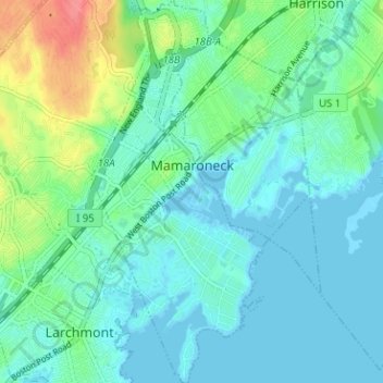
Name: Topografische Karte Village of Mamaroneck, Höhe, Relief.
Durchschnittliche Höhe: 15 m
Minimale Höhe: -3 m
Maximale Höhe: 65 m
Other areas of the town include Heathcote Hill, overlooking the harbor, Harbor Heights (the heights) to the northeast, Old Rye Neck (settled in the 1880s), Rye Neck (settled in the 1920s and 1930s), Orienta, and Washingtonville, better known as "The Flats", due to the flat, low-lying topography of the area.
Andere topografische Karten
Klicken Sie auf eine Karte, um ihre Topografie, ihre Höhe und ihr Relief anzuzeigen.
Village of Larchmont
United States > New York > Westchester County > Town of Mamaroneck
Village of Larchmont, Town of Mamaroneck, Westchester County, New York, 10538, United States
Durchschnittliche Höhe: 8 m