
Topografische Karte Lach
Interaktive Karte
Klicken Sie auf die Karte, um die Höhe anzuzeigen.
Lach
Die Gemeinde Lalaye liegt in den Vogesen im Tal des Ill-Nebenflusses Giessen, drei Kilometer von Villé entfernt. Dieser nimmt dort den Fluss „Le Charbe“ auf. Auf der westlichen Seite, beim Vallon de charbes, befindet sich mit dem Mont der höchste Punkt der Gemeindegemarkung auf 822 m über dem Meer. Südlich der Talschaft, auf der Höhe von Lalaye, bilden der Mont, der rund 500 m hohe Kohlberg und der 610 m hohe Goutte Henri einen Gebirgskamm. Zu Lalaye gehören die Ortsteile Blanc-Noyer, Chindé, Charbes, Grande Basse, Pransureux, Sachelingoutte und Wachtembert.
Über diese Karte
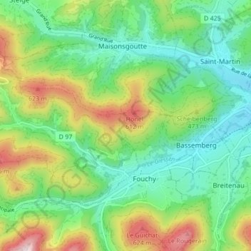
Name: Topografische Karte Lach, Höhe, Relief.
Durchschnittliche Höhe: 409 m
Minimale Höhe: 266 m
Maximale Höhe: 699 m
Andere topografische Karten
Klicken Sie auf eine Karte, um ihre Topografie, ihre Höhe und ihr Relief anzuzeigen.
Oberrheinische Tiefebene
Frankreich > Grand Est > Unterelsass > Herrlisheim
Die Oberrheinische Tiefebene wird vom Rhein – und zwar von seinem etwa 350 km langen Abschnitt Oberrhein, nach dem sie benannt ist – durchflossen. Der südlichste Teil der Ebene liegt in der Nordwestschweiz um die Stadt Basel, der südwestliche Abschnitt in den nordostfranzösischen Départements Haut-Rhin…
Durchschnittliche Höhe: 397 m