
Topografische Karte Ocheyedan Mound
Interaktive Karte
Klicken Sie auf die Karte, um die Höhe anzuzeigen.
Über diese Karte
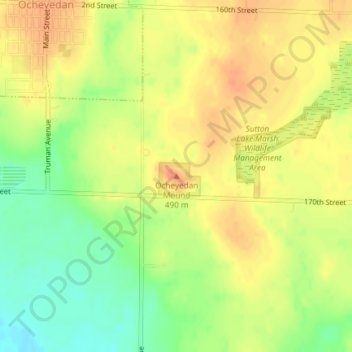
Name: Topografische Karte Ocheyedan Mound, Höhe, Relief.
Ort: Ocheyedan Mound, Osceola County, Iowa, 51354, USA (43.40270 -95.52117 43.40280 -95.52107)
Durchschnittliche Höhe: 466 m
Minimale Höhe: 441 m
Maximale Höhe: 483 m
Andere topografische Karten
Klicken Sie auf eine Karte, um ihre Topografie, ihre Höhe und ihr Relief anzuzeigen.
West Okoboji Lake
West Okoboji Lake, Fairfield Street, Okoboji, Dickinson County, Iowa, 51355, USA
Durchschnittliche Höhe: 437 m
Rathbun Lake
Rathbun Lake, 150th Avenue, Iconium, Appanoose County, Iowa, 52571, USA
Durchschnittliche Höhe: 292 m
Ballyclough
USA > Iowa > Ballyclough
Ballyclough, Dubuque County, Iowa, 52003, USA
Durchschnittliche Höhe: 281 m
Manikowski Prairie State Preserve
Manikowski Prairie State Preserve, 137th Street, Bryant, Clinton County, Iowa, 52750, USA
Durchschnittliche Höhe: 218 m
Cheever Lake
Cheever Lake, 190th Street, Raleigh, Emmet County, Iowa, 51334, USA
Durchschnittliche Höhe: 441 m
Saylorville Lake
Saylorville Lake, Lakeshore Trail, Andrews, Polk County, Iowa, USA
Durchschnittliche Höhe: 282 m
Anderson Prairie
Anderson Prairie, Ridge Road, Decorah, Winneshiek County, Iowa, 52101, USA
Durchschnittliche Höhe: 301 m
Pony Creek Lake
USA > Iowa > Pacific City
Pony Creek Lake, Deacon Road, Pacific Junction, Pacific City, Mills County, Iowa, 51561, USA
Durchschnittliche Höhe: 350 m
Malanaphy Springs State Preserve
Malanaphy Springs State Preserve, Winneshiek County, Iowa, USA
Durchschnittliche Höhe: 300 m
Calkin's Nature Area
Calkin's Nature Area, 135th Street, Hardin County, Iowa, 50126, USA
Durchschnittliche Höhe: 349 m
Lost Island Lake
Lost Island Lake, 340th Avenue, Palo Alto County, Iowa, 51358, USA
Durchschnittliche Höhe: 412 m
Lake Ahquabi
Lake Ahquabi, Nixon Street, Warren County, Iowa, 50125, USA
Durchschnittliche Höhe: 275 m
Beeds Lake
Beeds Lake, Beeds Lake Drive, Franklin County, Iowa, 50441, USA
Durchschnittliche Höhe: 351 m
Lake Red Rock
Lake Red Rock, 146th Avenue, Cordova, Marion County, Iowa, 50138, USA
Durchschnittliche Höhe: 248 m
Cayler Prairie State Preserve
Cayler Prairie State Preserve, Dickinson County, Iowa, USA
Durchschnittliche Höhe: 438 m
Ambrose A Call State Park
Ambrose A Call State Park, Hobarton, Kossuth County, Iowa, USA
Durchschnittliche Höhe: 364 m
Elinor Bedell State Park
Elinor Bedell State Park, Dickinson County, Iowa, USA
Durchschnittliche Höhe: 443 m
Randleman Lake
USA > Iowa > Woodland Hills
Randleman Lake, Backpacker Trail, Woodland Hills, Polk County, Iowa, 50047, USA
Durchschnittliche Höhe: 239 m
Lake Keomah
Lake Keomah, Keomah Lake Trail, Wright, Mahaska County, Iowa, USA
Durchschnittliche Höhe: 242 m
Kish-Ke-Kosh Prairie State Preserve
Kish-Ke-Kosh Prairie State Preserve, Robin Avenue, Reasnor, Jasper County, Iowa, 50232, USA
Durchschnittliche Höhe: 242 m
Lake Wapello
Lake Wapello, Access Trail, Blackhawk, Davis County, Iowa, USA
Durchschnittliche Höhe: 254 m
Margo Frankel Woods State Park
USA > Iowa > Saylorville
Margo Frankel Woods State Park, Northwest 2nd Street, Saylorville, Polk County, Iowa, 50023-9723, USA
Durchschnittliche Höhe: 273 m
Twin View Heights
USA > Iowa > Twin View Heights
Twin View Heights, Johnson County, Iowa, 52333, USA
Durchschnittliche Höhe: 221 m
Hartman Reserve Nature Center
Hartman Reserve Nature Center, Waterloo, Black Hawk County, Iowa, USA
Durchschnittliche Höhe: 270 m
Kuehn Conservation Area
Kuehn Conservation Area, Kennedy, Dallas County, Iowa, USA
Durchschnittliche Höhe: 294 m
East Okoboji Lake
East Okoboji Lake, Shoreline Drive, Dickinson County, Iowa, 51360, USA
Durchschnittliche Höhe: 448 m
McCausland
USA > Iowa > McCausland
McCausland, Scott County, Iowa, 52758, USA
Durchschnittliche Höhe: 185 m
Starr's Cave Nature Center
USA > Iowa > Green Acres Mobile Home Park
Starr's Cave Nature Center, West Burlington, Green Acres Mobile Home Park, Des Moines County, Iowa, 52601, USA
Durchschnittliche Höhe: 192 m