
Topografische Karte Square Butte
Interaktive Karte
Klicken Sie auf die Karte, um die Höhe anzuzeigen.
Über diese Karte
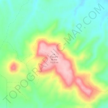
Name: Topografische Karte Square Butte, Höhe, Relief.
Durchschnittliche Höhe: 884 m
Minimale Höhe: 805 m
Maximale Höhe: 1.009 m
Andere topografische Karten
Klicken Sie auf eine Karte, um ihre Topografie, ihre Höhe und ihr Relief anzuzeigen.
Forman
United States of America > North Dakota > Forman
Forman, Sargent County, North Dakota, 58032, United States of America
Durchschnittliche Höhe: 383 m
Tongue River
United States of America > North Dakota
Tongue River, Pembina County, North Dakota, United States of America
Durchschnittliche Höhe: 245 m
Parshall
United States of America > North Dakota > Parshall
Parshall, Mountrail County, North Dakota, United States of America
Durchschnittliche Höhe: 598 m
Pillsbury
United States of America > North Dakota > Pillsbury > Pillsbury
Pillsbury, Barnes County, North Dakota, United States of America
Durchschnittliche Höhe: 388 m