
Topografische Karte Sereď
Interaktive Karte
Klicken Sie auf die Karte, um die Höhe anzuzeigen.
Über diese Karte
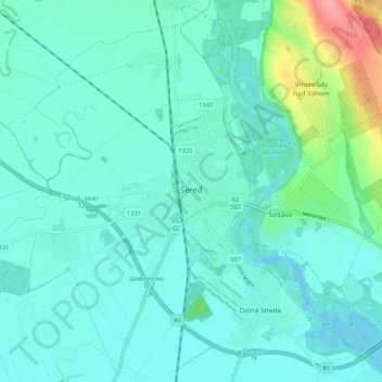
Name: Topografische Karte Sereď, Höhe, Relief.
Durchschnittliche Höhe: 132 m
Minimale Höhe: 117 m
Maximale Höhe: 204 m
Sereď lies at an altitude of 129 metres (423 ft) above sea level and covers an area of 30.454 square kilometres (11.8 sq mi). It is located in the Danubian Lowland on the Váh river, around 20 kilometres (12 mi) south-east of Trnava, 33 kilometres (21 mi) west of Nitra and around 55 kilometres (34 mi) east from Bratislava. The closest mountain ranges are the Little Carpathians to the west and Považský Inovec to the north.
Andere topografische Karten
Klicken Sie auf eine Karte, um ihre Topografie, ihre Höhe und ihr Relief anzuzeigen.
Sládkovičovo
Slovakia > Region of Trnava > District of Galanta
Sládkovičovo, District of Galanta, Region of Trnava, Western Slovakia, 925 21, Slovakia
Durchschnittliche Höhe: 120 m
Šintava
Slovakia > Region of Trnava > District of Galanta
Šintava, District of Galanta, Region of Trnava, Western Slovakia, 925 51, Slovakia
Durchschnittliche Höhe: 138 m