
Topografische Karte Hilongos
Interaktive Karte
Klicken Sie auf die Karte, um die Höhe anzuzeigen.
Über diese Karte
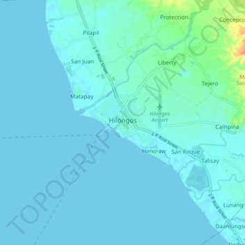
Name: Topografische Karte Hilongos, Höhe, Relief.
Durchschnittliche Höhe: 4 m
Minimale Höhe: -3 m
Maximale Höhe: 39 m
Andere topografische Karten
Klicken Sie auf eine Karte, um ihre Topografie, ihre Höhe und ihr Relief anzuzeigen.
Campina
Philippines > Leyte > Hilongos
Campina, Hilongos, 5th District, Leyte, Eastern Visayas, 6524, Philippines
Durchschnittliche Höhe: 10 m
Children's Park
Philippines > Leyte > Hilongos > Atabay
Children's Park, Atabay, Hilongos, 5th District, Leyte, Eastern Visayas, 6524, Philippines
Durchschnittliche Höhe: 3 m
Lake
Philippines > Leyte > Hilongos > Atabay
Lake, Atabay, Hilongos, Leyte 5th District, Leyte, Eastern Visayas, 6524, Philippines
Durchschnittliche Höhe: 2 m
Salog River
Philippines > Leyte > Hilongos
Salog River, Hilongos, Leyte 5th District, Leyte, Eastern Visayas, 6524, Philippines
Durchschnittliche Höhe: 91 m