
Topografische Karte Nedlands
Interaktive Karte
Klicken Sie auf die Karte, um die Höhe anzuzeigen.
Über diese Karte
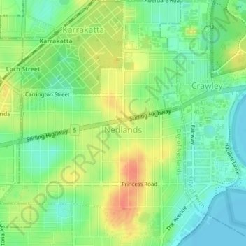
Name: Topografische Karte Nedlands, Höhe, Relief.
Durchschnittliche Höhe: 20 m
Minimale Höhe: 0 m
Maximale Höhe: 46 m
Due to its elevation, Nedlands is slightly cooler and wetter than the Perth central business district.
Andere topografische Karten
Klicken Sie auf eine Karte, um ihre Topografie, ihre Höhe und ihr Relief anzuzeigen.
Dalkeith
Australia > Western Australia > City of Nedlands
Dalkeith, City of Nedlands, Western Australia, Australia
Durchschnittliche Höhe: 14 m
Mount Claremont
Australia > Western Australia > City of Nedlands
Mount Claremont, City of Nedlands, Western Australia, Australia
Durchschnittliche Höhe: 23 m
Allen Park Bushland
Australia > Western Australia > City of Nedlands
Allen Park Bushland, Swanbourne, City of Nedlands, Western Australia, 6910, Australia
Durchschnittliche Höhe: 15 m