
Topografische Karte Rikers Island
Interaktive Karte
Klicken Sie auf die Karte, um die Höhe anzuzeigen.
Über diese Karte
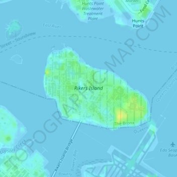
Name: Topografische Karte Rikers Island, Höhe, Relief.
Ort: Rikers Island, The Bronx, New York, États-Unis d'Amérique (40.78537 -73.89269 40.79838 -73.87089)
Durchschnittliche Höhe: 2 m
Minimale Höhe: -12 m
Maximale Höhe: 18 m
Andere topografische Karten
Klicken Sie auf eine Karte, um ihre Topografie, ihre Höhe und ihr Relief anzuzeigen.
Manhattan
États-Unis d'Amérique > New York > New York
Harlem, Manhattan Community Board 10, Manhattan, New York County, New York, États-Unis d'Amérique
Durchschnittliche Höhe: 16 m
Queens
États-Unis d'Amérique > New York > New York
Queens, New York, États-Unis d'Amérique
Durchschnittliche Höhe: 11 m
Brooklyn
États-Unis d'Amérique > New York > New York
Brooklyn, Kings County, New York, États-Unis d'Amérique
Durchschnittliche Höhe: 9 m
Greenwich Village
États-Unis d'Amérique > New York > New York
Greenwich Village, Manhattan Community Board 2, Manhattan, New York County, New York, États-Unis d'Amérique
Durchschnittliche Höhe: 16 m
Bronx County
États-Unis d'Amérique > New York > New York
Bronx County, The Bronx, New York, États-Unis d'Amérique
Durchschnittliche Höhe: 21 m
Peter Detmold Park Dog Run
États-Unis d'Amérique > New York > New York
Peter Detmold Park Dog Run, West of FDR Drive, Turtle Bay, Manhattan Community Board 6, Manhattan, New York County, New York, 10017, États-Unis d'Amérique
Durchschnittliche Höhe: 14 m
New York County
États-Unis d'Amérique > New York > New York
New York County, New York, États-Unis d'Amérique
Durchschnittliche Höhe: 16 m
Kings County
États-Unis d'Amérique > New York > New York
Kings County, New York, États-Unis d'Amérique
Durchschnittliche Höhe: 9 m
Richmond County
États-Unis d'Amérique > New York > New York
Richmond County, New York, États-Unis d'Amérique
Durchschnittliche Höhe: 9 m
Queens County
États-Unis d'Amérique > New York > New York
Queens County, New York, États-Unis d'Amérique
Durchschnittliche Höhe: 11 m