
Topografische Karte Youyu County
Interaktive Karte
Klicken Sie auf die Karte, um die Höhe anzuzeigen.
Über diese Karte
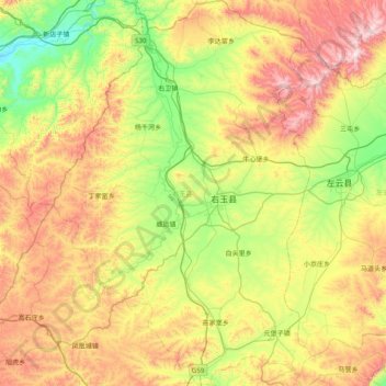
Name: Topografische Karte Youyu County, Höhe, Relief.
Ort: Youyu County, Shuozhou City, Shanxi, China (39.69259 112.11211 40.29863 112.64180)
Durchschnittliche Höhe: 1.486 m
Minimale Höhe: 1.130 m
Maximale Höhe: 2.058 m
Elevations are generally higher in the south of the county, in which flows the Cangtou River (苍头河); Youyu reaches a north-south extent of 67.7 km (42.1 mi) and east-west width of 45.7 km (28.4 mi). The Great Wall demarcates the northwestern border with Inner Mongolia's Liangcheng and Horinger counties; within the province, Youyu borders Zuoyun County to the east, Shanyin County and Pinglu District to the south.
Andere topografische Karten
Klicken Sie auf eine Karte, um ihre Topografie, ihre Höhe und ihr Relief anzuzeigen.
Xiangfen County
Xiangfen County, Linfen, Shanxi, 041500, China
Durchschnittliche Höhe: 614 m
Pingyao County
China > Shanxi > Jinzhong City
Pingyao County, Jinzhong City, Shanxi, 031100, China
Durchschnittliche Höhe: 1.128 m
Hejin
China > Shanxi > Hejin City > Chengqu Subdistrict
Hejin, Chengqu Subdistrict, Hejin City, Yuncheng City, Shanxi, 043300, China
Durchschnittliche Höhe: 529 m
Linyi
China > Shanxi > Linyi County
Linyi, Linyi County, Yuncheng City, Shanxi, China
Durchschnittliche Höhe: 455 m
Shiba
China > Shanxi > Ningwu County > Shiba
Shiba, Ningwu County, Xinzhou City, Shanxi, China
Durchschnittliche Höhe: 1.599 m
Xiangning County
Xiangning County, Linfen City, Shanxi, China
Durchschnittliche Höhe: 977 m
Pingcheng District
China > Shanxi > Pingcheng District
Datong, Pingcheng District, Datong City, Shanxi, 037004, China
Durchschnittliche Höhe: 1.149 m
Gulou Subdistrict
China > Shanxi > Gulou Subdistrict
Gulou Subdistrict, Huozhou City, Linfen Shi, Shanxi, China
Durchschnittliche Höhe: 560 m
Yuncheng
China > Shanxi > Dongcheng Subdistrict
Yuncheng, Dongcheng Subdistrict, Yanhu District, Yuncheng City, Shanxi, 044031, China
Durchschnittliche Höhe: 478 m