Geolokalisieren

Topografische Karte Ballard County

Interaktive Karte

Klicken Sie auf die Karte, um die Höhe anzuzeigen.

Über diese Karte

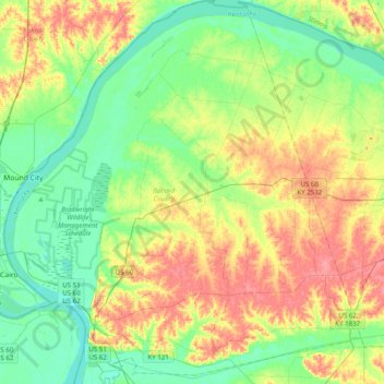
Name: Topografische Karte Ballard County, Höhe, Relief.

Ort: Ballard County, Kentucky, USA (36.91546 -89.18251 37.22989 -88.81583)

Durchschnittliche Höhe: 113 m

Minimale Höhe: 87 m

Maximale Höhe: 153 m

Andere topografische Karten

Klicken Sie auf eine Karte, um ihre Topografie, ihre Höhe und ihr Relief anzuzeigen.

Marion

USA > Kentucky > Marion

Marion, Crittenden County, Kentucky, USA

Durchschnittliche Höhe: 182 m

Westwood

USA > Kentucky > Westwood

Westwood, Jefferson County, Kentucky, USA

Durchschnittliche Höhe: 196 m

Madisonville

USA > Kentucky > Madisonville

Madisonville, Hopkins County, Kentucky, 42431, USA

Durchschnittliche Höhe: 136 m

Covington

USA > Kentucky > Covington

Covington, Kenton County, Kentucky, USA

Durchschnittliche Höhe: 215 m

New Haven

USA > Kentucky > New Haven

New Haven, Nelson County, Kentucky, USA

Durchschnittliche Höhe: 153 m

Ulysses

USA > Kentucky > Ulysses

Ulysses, Lawrence County, Kentucky, 41264, USA

Durchschnittliche Höhe: 238 m

Bowling Green

USA > Kentucky > Bowling Green

Bowling Green, Warren County, Kentucky, 42101, USA

Durchschnittliche Höhe: 169 m

Grayson County

USA > Kentucky

Grayson County, Kentucky, USA

Durchschnittliche Höhe: 196 m

Lexington

USA > Kentucky > Lexington

Lexington, Fayette County, Kentucky, 40508, USA

Durchschnittliche Höhe: 285 m

Music

USA > Kentucky > Music

Music, Carter County, Kentucky, USA

Durchschnittliche Höhe: 264 m

Cyclone

USA > Kentucky > Eddyville

Cyclone, Eddyville, Lyon County, Kentucky, USA

Durchschnittliche Höhe: 139 m

Georgetown

USA > Kentucky > Georgetown

Georgetown, Scott County, Kentucky, 40324, USA

Durchschnittliche Höhe: 265 m

Mammoth Cave

USA > Kentucky > Mammoth Cave

Mammoth Cave, Edmonson County, Kentucky, USA

Durchschnittliche Höhe: 214 m