
Topografische Karte Villa Pehuenia
Interaktive Karte
Klicken Sie auf die Karte, um die Höhe anzuzeigen.
Über diese Karte
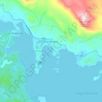
Name: Topografische Karte Villa Pehuenia, Höhe, Relief.
Durchschnittliche Höhe: 1.240 m
Minimale Höhe: 1.145 m
Maximale Höhe: 1.759 m
Villa Pehuenia sprawls over about 5 kilometres (3.1 mi) of the northern shore of Lake Aluminé, but is concentrated on two narrow peninsulas extending out into the lake. Rising near the village is the Batea Mahuida volcano which reaches a maximum elevation of 1,948 metres (6,391 ft) about 8 kilometres (5.0 mi) north of the Villa Pehuenia. A small ski resort is operated on the slopes of the volcano by the Puel people.
Andere topografische Karten
Klicken Sie auf eine Karte, um ihre Topografie, ihre Höhe und ihr Relief anzuzeigen.
Villa La Angostura
Argentina > Neuquén Province > Villa La Angostura
Villa La Angostura, Departamento Los Lagos, Neuquén Province, Argentina
Durchschnittliche Höhe: 928 m