
Topografische Karte San Mateo
Interaktive Karte
Klicken Sie auf die Karte, um die Höhe anzuzeigen.
Über diese Karte
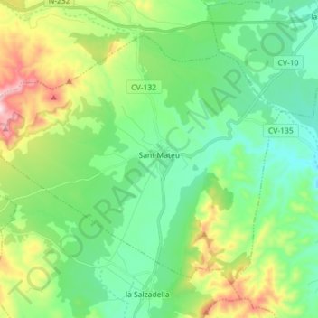
Name: Topografische Karte San Mateo, Höhe, Relief.
Durchschnittliche Höhe: 393 m
Minimale Höhe: 237 m
Maximale Höhe: 784 m
Andere topografische Karten
Klicken Sie auf eine Karte, um ihre Topografie, ihre Höhe und ihr Relief anzuzeigen.
Altura
España > Comunidad Valenciana > Castellón
Altura, El Alto Palancia, Castellón, Comunidad Valenciana, España
Durchschnittliche Höhe: 524 m
Ceja la Redonda
España > Comunidad Valenciana > Castellón > Pina de Montalgrao
Ceja la Redonda, Pina de Montalgrao, El Alto Palancia, Castellón, Comunidad Valenciana, 12420, España
Durchschnittliche Höhe: 1.062 m
Vinaroz
España > Comunidad Valenciana > Castellón
Vinaroz, Bajo Maestrazgo, Castellón, Comunidad Valenciana, 12500, España
Durchschnittliche Höhe: 54 m
Castellón de la Plana
España > Comunidad Valenciana > Castellón
Castellón de la Plana, Plana Alta, Castellón, Comunidad Valenciana, España
Durchschnittliche Höhe: 216 m
Benicasim
España > Comunidad Valenciana > Castellón > Benicasim
Benicasim, Plana Alta, Castellón, Comunidad Valenciana, 12560, España
Durchschnittliche Höhe: 107 m