
Topografische Karte Besalú
Interaktive Karte
Klicken Sie auf die Karte, um die Höhe anzuzeigen.
Über diese Karte
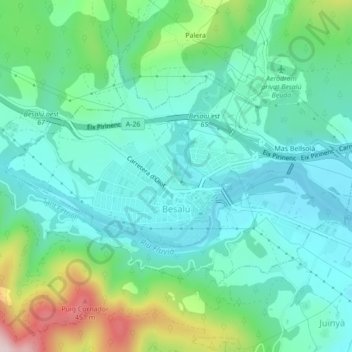
Name: Topografische Karte Besalú, Höhe, Relief.
Ort: Besalú, Garrotxa, Gérone, Catalogne, 17850, Espagne (42.19225 2.67481 42.21104 2.71817)
Durchschnittliche Höhe: 213 m
Minimale Höhe: 126 m
Maximale Höhe: 480 m
Andere topografische Karten
Klicken Sie auf eine Karte, um ihre Topografie, ihre Höhe und ihr Relief anzuzeigen.
la Vall de Bianya
Espagne > Catalogne > Garrotxa
la Vall de Bianya, Garrotxa, Gérone, Catalogne, 17813, Espagne
Durchschnittliche Höhe: 722 m
les Planes d'Hostoles
Espagne > Catalogne > Garrotxa
les Planes d'Hostoles, Garrotxa, Gérone, Catalogne, 17172, Espagne
Durchschnittliche Höhe: 601 m
Sant Esteve d'en Bas
Espagne > Catalogne > Garrotxa > la Vall d'en Bas
Sant Esteve d'en Bas, la Vall d'en Bas, Garrotxa, Gérone, Catalogne, 17176, Espagne
Durchschnittliche Höhe: 560 m
Castellfollit de la Roca
Espagne > Catalogne > Garrotxa
Castellfollit de la Roca, Garrotxa, Gérone, Catalogne, 17856, Espagne
Durchschnittliche Höhe: 389 m