
Topografische Karte Rayside
Interaktive Karte
Klicken Sie auf die Karte, um die Höhe anzuzeigen.
Über diese Karte
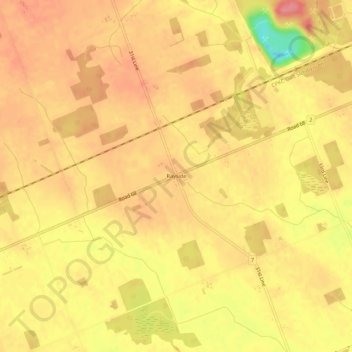
Name: Topografische Karte Rayside, Höhe, Relief.
Ort: Rayside, Zorra, Oxford County, Ontario, N5C 2P7, Canada (43.06305 -80.93911 43.10305 -80.89911)
Durchschnittliche Höhe: 303 m
Minimale Höhe: 242 m
Maximale Höhe: 331 m
Andere topografische Karten
Klicken Sie auf eine Karte, um ihre Topografie, ihre Höhe und ihr Relief anzuzeigen.
Oliver
Canada > Ontario > Oxford County > Zorra
Oliver, Zorra, Oxford County, Southwestern Ontario, Ontario, Canada
Durchschnittliche Höhe: 327 m
Harrington
Canada > Ontario > Oxford County > Zorra
Harrington, Zorra, Oxford County, Southwestern Ontario, Ontario, Canada
Durchschnittliche Höhe: 346 m
Thamesford
Canada > Ontario > Oxford County > Zorra
Thamesford, Zorra, Oxford County, Ontario, N0M 2M0, Canada
Durchschnittliche Höhe: 291 m
Thamesford
Canada > Ontario > Oxford County > Zorra > Thamesford
Thamesford, Zorra, Oxford County, Southwestern Ontario, Ontario, N0M 2M0, Canada
Durchschnittliche Höhe: 290 m