
Topografische Karte Réserve naturelle du Frankenthal-Missheimle
Interaktive Karte
Klicken Sie auf die Karte, um die Höhe anzuzeigen.
Über diese Karte
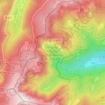
Name: Topografische Karte Réserve naturelle du Frankenthal-Missheimle, Höhe, Relief.
Durchschnittliche Höhe: 1.003 m
Minimale Höhe: 502 m
Maximale Höhe: 1.352 m
Andere topografische Karten
Klicken Sie auf eine Karte, um ihre Topografie, ihre Höhe und ihr Relief anzuzeigen.
Lac de Schiessrothried
France > Grand Est > Stosswihr
Lac de Schiessrothried, Sentier des Couloirs, Stosswihr, Colmar-Ribeauvillé, Haut-Rhin, Grand Est, France métropolitaine, 68140, France
Durchschnittliche Höhe: 1.074 m
La Grotte Dagobert
France > Grand Est > Stosswihr
La Grotte Dagobert, Sentier des Couloirs, Stosswihr, Colmar-Ribeauvillé, Haut-Rhin, Grand Est, France métropolitaine, 68140, France
Durchschnittliche Höhe: 1.121 m
Petit Cervin
France > Grand Est > Stosswihr
Petit Cervin, Sentier du Falimont, Stosswihr, Colmar-Ribeauvillé, Haut-Rhin, Grand Est, France métropolitaine, 68140, France
Durchschnittliche Höhe: 1.131 m