
Spenden
Rüsten Sie sich für Ihr nächstes Abenteuer:
Als Amazon-Partner erhält diese Website eine Provision für qualifizierte Käufe, ohne zusätzliche Kosten für Sie.
Topografische Karte Târgu Mureș
Klicken Sie auf die Karte, um die Höhe anzuzeigen.
Spenden
Rüsten Sie sich für Ihr nächstes Abenteuer:
Als Amazon-Partner erhält diese Website eine Provision für qualifizierte Käufe, ohne zusätzliche Kosten für Sie.
Târgu Mureș
The old City Hall was built in 1906–1907 after the construction plans of Márcell Komor and Dezső Jakab. The entrance area, including the corridor and the staircase leading to the first floor, is the most representative in this regard. The ribbed stellar vaults that cover this area were inspired by Gothic architecture. The vaults are supported by columns with composite caps, and the keystone is a large floral shape which includes the lighting appliance. The vaults are painted with spiraling vegetal motifs. Elements of the front hall include the stone bench with its legs shaped as those of an animal and with wing-shaped handles. Its shell-shaped, golden back has a shield flanked by two volutes on its upper side. Features of the monumental staircase leading to the first floor include the upper side of the banister resembling a slithering animal or a wave. The exterior decoration is simpler and is based on Hungarian-Székely folk motives made of polychromatic ceramics. The ground floor is marked by a solid, embossed pedestal. Windows with large openings tend to be predominant in the façade. The three semicircular windows in the middle area of the façade are those of the honor hall that has a double elevation with respect to the other rooms. The glass paintings which illustrated Gábor Bethlen, Francis II Rákóczi, Lajos Kossuth, Ferenc Deák and Franz Joseph I of Austria are missing from the halls.
Spenden
Rüsten Sie sich für Ihr nächstes Abenteuer:
Als Amazon-Partner erhält diese Website eine Provision für qualifizierte Käufe, ohne zusätzliche Kosten für Sie.
Über diese Karte
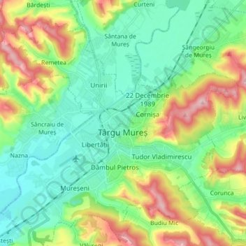
Name: Topografische Karte Târgu Mureș, Höhe, Relief.
Ort: Târgu Mureș, Targu Mures Metropolitan Area, Mureș, Romania (46.50002 24.49187 46.59617 24.62685)
Durchschnittliche Höhe: 357 m
Minimale Höhe: 296 m
Maximale Höhe: 486 m
Spenden
Rüsten Sie sich für Ihr nächstes Abenteuer:
Als Amazon-Partner erhält diese Website eine Provision für qualifizierte Käufe, ohne zusätzliche Kosten für Sie.
Andere topografische Karten
Klicken Sie auf eine Karte, um ihre Topografie, ihre Höhe und ihr Relief anzuzeigen.
Spenden
Rüsten Sie sich für Ihr nächstes Abenteuer:
Als Amazon-Partner erhält diese Website eine Provision für qualifizierte Käufe, ohne zusätzliche Kosten für Sie.
Spenden
Rüsten Sie sich für Ihr nächstes Abenteuer:
Als Amazon-Partner erhält diese Website eine Provision für qualifizierte Käufe, ohne zusätzliche Kosten für Sie.
Spenden
Rüsten Sie sich für Ihr nächstes Abenteuer:
Als Amazon-Partner erhält diese Website eine Provision für qualifizierte Käufe, ohne zusätzliche Kosten für Sie.
Spenden
Rüsten Sie sich für Ihr nächstes Abenteuer:
Als Amazon-Partner erhält diese Website eine Provision für qualifizierte Käufe, ohne zusätzliche Kosten für Sie.
Spenden
Rüsten Sie sich für Ihr nächstes Abenteuer:
Als Amazon-Partner erhält diese Website eine Provision für qualifizierte Käufe, ohne zusätzliche Kosten für Sie.
Spenden
Rüsten Sie sich für Ihr nächstes Abenteuer:
Als Amazon-Partner erhält diese Website eine Provision für qualifizierte Käufe, ohne zusätzliche Kosten für Sie.
Spenden
Rüsten Sie sich für Ihr nächstes Abenteuer:
Als Amazon-Partner erhält diese Website eine Provision für qualifizierte Käufe, ohne zusätzliche Kosten für Sie.
Spenden
Rüsten Sie sich für Ihr nächstes Abenteuer:
Als Amazon-Partner erhält diese Website eine Provision für qualifizierte Käufe, ohne zusätzliche Kosten für Sie.
Spenden
Rüsten Sie sich für Ihr nächstes Abenteuer:
Als Amazon-Partner erhält diese Website eine Provision für qualifizierte Käufe, ohne zusätzliche Kosten für Sie.
Spenden
Rüsten Sie sich für Ihr nächstes Abenteuer:
Als Amazon-Partner erhält diese Website eine Provision für qualifizierte Käufe, ohne zusätzliche Kosten für Sie.