Topografische Karte Lac Edward
Interaktive Karte
Klicken Sie auf die Karte, um die Höhe anzuzeigen.
Über diese Karte
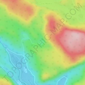
Name: Topografische Karte Lac Edward, Höhe, Relief.
Ort: Lac Edward, Mandeville, D'Autray, Lanaudière, Québec, Canada (46.46914 -73.47594 46.47049 -73.47393)
Durchschnittliche Höhe: 374 m
Minimale Höhe: 276 m
Maximale Höhe: 502 m
Andere topografische Karten
Klicken Sie auf eine Karte, um ihre Topografie, ihre Höhe und ihr Relief anzuzeigen.
Lac Long
Canada > Québec > D'Autray > Mandeville
Lac Long, Mandeville, D'Autray, Lanaudière, Québec, Canada
Durchschnittliche Höhe: 251 m
Lac McGrey
Canada > Québec > D'Autray > Mandeville
Lac McGrey, Mandeville, D'Autray, Lanaudière, Québec, Canada
Durchschnittliche Höhe: 346 m
Lac des Chevreaux
Canada > Québec > D'Autray > Mandeville
Lac des Chevreaux, Mandeville, D'Autray, Lanaudière, Québec, Canada
Durchschnittliche Höhe: 462 m
Lac aux Bouleaux
Canada > Québec > D'Autray > Mandeville
Lac aux Bouleaux, Mandeville, D'Autray, Lanaudière, Québec, Canada
Durchschnittliche Höhe: 377 m
Lac Mandeville
Canada > Québec > D'Autray > Mandeville
Lac Mandeville, Mandeville, D'Autray, Lanaudière, Québec, Canada
Durchschnittliche Höhe: 173 m
Rivière Mandeville
Canada > Québec > D'Autray > Mandeville > Saint-Charles-de-Mandeville
Rivière Mandeville, Saint-Charles-de-Mandeville, Mandeville, D'Autray, Lanaudière, Québec, Canada
Durchschnittliche Höhe: 229 m
Saint-Charles-de-Mandeville
Canada > Québec > D'Autray > Mandeville
Saint-Charles-de-Mandeville, Mandeville, D'Autray, Lanaudière, Québec, J0K 1L0, Canada
Durchschnittliche Höhe: 167 m