
Topografische Karte Edmonton
Interaktive Karte
Klicken Sie auf die Karte, um die Höhe anzuzeigen.
Über diese Karte
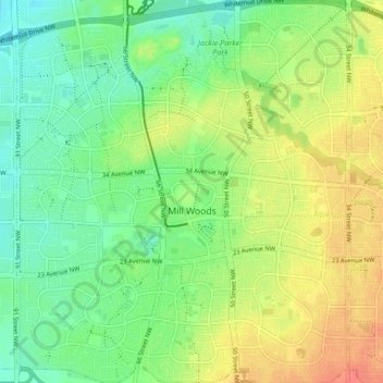
Name: Topografische Karte Edmonton, Höhe, Relief.
Ort: Mill Woods, Edmonton, Alberta, Canada (53.43772 -113.46691 53.48769 -113.39361)
Durchschnittliche Höhe: 698 m
Minimale Höhe: 677 m
Maximale Höhe: 725 m
Andere topografische Karten
Klicken Sie auf eine Karte, um ihre Topografie, ihre Höhe und ihr Relief anzuzeigen.
Lake District
Lake District, Edmonton, Alberta, Canada
Durchschnittliche Höhe: 684 m
Lakewood
Canada > Alberta > Edmonton > Mill Woods
Lakewood, Mill Woods, Edmonton, Alberta, Canada
Durchschnittliche Höhe: 689 m
The Meadows District
Larkspur, West Meadows, The Meadows District, Edmonton, Alberta, Canada
Durchschnittliche Höhe: 707 m
Central Core
Downtown, Central Core, Edmonton, Alberta, Canada
Durchschnittliche Höhe: 653 m
The Meadows
Tamarack, The Meadows, Edmonton, Alberta, Canada
Durchschnittliche Höhe: 718 m