
Topografische Karte Harare
Interaktive Karte
Klicken Sie auf die Karte, um die Höhe anzuzeigen.
Über diese Karte
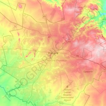
Name: Topografische Karte Harare, Höhe, Relief.
Ort: Harare, Zimbabwe (-17.99177 30.88569 -17.67177 31.20569)
Durchschnittliche Höhe: 1.470 m
Minimale Höhe: 1.328 m
Maximale Höhe: 1.603 m
The city proper has an area of 982.3km2 (378.7 mi2), a population of 1,849,600 as of the 2022 census and an estimated 2,487,209 people in its metropolitan province. The city is situated in north-eastern Zimbabwe in the country's Mashonaland region. Harare is a metropolitan province, which also incorporates the municipalities of Chitungwiza and Epworth. The city sits on a plateau at an elevation of 1,483 metres (4,865 feet) above sea level, and its climate falls into the subtropical highland category.