
Topografische Karte Stockton
Interaktive Karte
Klicken Sie auf die Karte, um die Höhe anzuzeigen.
Über diese Karte
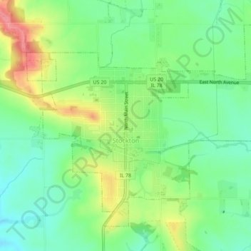
Name: Topografische Karte Stockton, Höhe, Relief.
Durchschnittliche Höhe: 301 m
Minimale Höhe: 267 m
Maximale Höhe: 356 m
The village water tower sits on a ridge at elevation 1,105 ft (337 m) that rises to 1,120 ft (340 m) to the west at the village limits. To the northwest the same ridge line continues where U.S. Route 20 crests at 1,077 ft (328 m) just to the west. This ridge line continues for 3 miles to the northwest to Benton Mound (1,204 ft; 367 m ), the second highest peak in Illinois.
Andere topografische Karten
Klicken Sie auf eine Karte, um ihre Topografie, ihre Höhe und ihr Relief anzuzeigen.
Hanover Township
United States > Illinois > Jo Daviess County
Hanover Township, Jo Daviess County, Illinois, 61041, United States
Durchschnittliche Höhe: 213 m
Galena
United States > Illinois > Jo Daviess County
Galena, Jo Daviess County, Illinois, United States
Durchschnittliche Höhe: 230 m
Warren
United States > Illinois > Jo Daviess County
Warren, Warren Township, Jo Daviess County, Illinois, United States
Durchschnittliche Höhe: 306 m
Hanover
United States > Illinois > Jo Daviess County
Hanover, Hanover Township, Jo Daviess County, Illinois, 61041, United States
Durchschnittliche Höhe: 218 m
Elizabeth
United States > Illinois > Jo Daviess County
Elizabeth, Elizabeth Township, Jo Daviess County, Illinois, United States
Durchschnittliche Höhe: 230 m
East Dubuque
United States > Illinois > Jo Daviess County
East Dubuque, Jo Daviess County, Illinois, United States
Durchschnittliche Höhe: 207 m
Apple River
United States > Illinois > Jo Daviess County > Apple River
Apple River, Jo Daviess County, Illinois, United States
Durchschnittliche Höhe: 308 m