
Topografische Karte Blaeberry
Klicken Sie auf die Karte, um die Höhe anzuzeigen.
Über diese Karte
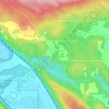
Name: Topografische Karte Blaeberry, Höhe, Relief.
Durchschnittliche Höhe: 846 m
Minimale Höhe: 775 m
Maximale Höhe: 977 m
Andere topografische Karten
Klicken Sie auf eine Karte, um ihre Topografie, ihre Höhe und ihr Relief anzuzeigen.
Lake O'Hara
Canada > British Columbia > Columbia-Shuswap Regional District > Area A (Kicking Horse/Kinbasket Lake)
Lake O'Hara is a lake at an elevation of 2,020 metres (6,630 ft) in the alpine area of Yoho National Park, in the province of British Columbia, on the western side of the Great Divide with the province of Alberta and Banff National Park to the east. The lake and the valley are accessible through a bus service…
Durchschnittliche Höhe: 2.276 m
Sherbrooke Lake
Canada > British Columbia > Columbia-Shuswap Regional District > Area A (Kicking Horse/Kinbasket Lake)
Durchschnittliche Höhe: 2.080 m
Windy Arm
Canada > British Columbia > Columbia-Shuswap Regional District > Area A (Kicking Horse/Kinbasket Lake)
Durchschnittliche Höhe: 1.009 m
Wapta Falls
Canada > British Columbia > Columbia-Shuswap Regional District > Area A (Kicking Horse/Kinbasket Lake)
Durchschnittliche Höhe: 1.145 m
Quartz Creek
Canada > British Columbia > Columbia-Shuswap Regional District > Area A (Kicking Horse/Kinbasket Lake)
Durchschnittliche Höhe: 1.352 m
Wapta Lake
Canada > British Columbia > Columbia-Shuswap Regional District > Area A (Kicking Horse/Kinbasket Lake)
Durchschnittliche Höhe: 1.757 m
Takakkaw Lake
Canada > British Columbia > Columbia-Shuswap Regional District > Area A (Kicking Horse/Kinbasket Lake)
Durchschnittliche Höhe: 2.143 m
Stanley Glacier
Canada > British Columbia > Columbia-Shuswap Regional District > Area A (Kicking Horse/Kinbasket Lake)
Durchschnittliche Höhe: 2.488 m
Wapta Icefield
Canada > British Columbia > Columbia-Shuswap Regional District > Area A (Kicking Horse/Kinbasket Lake)
Durchschnittliche Höhe: 2.564 m
Waputik Icefield
Canada > British Columbia > Columbia-Shuswap Regional District > Area A (Kicking Horse/Kinbasket Lake)
Durchschnittliche Höhe: 2.432 m
Rogers Glacier
Canada > British Columbia > Columbia-Shuswap Regional District > Area A (Kicking Horse/Kinbasket Lake)
Durchschnittliche Höhe: 2.499 m
Bugaboo Provincial Park
Canada > British Columbia > Columbia-Shuswap Regional District > Area A (Kicking Horse/Kinbasket Lake)
Durchschnittliche Höhe: 2.192 m
Bugaboo Provincial Park
Canada > British Columbia > Columbia-Shuswap Regional District > Area A (Kicking Horse/Kinbasket Lake)
Durchschnittliche Höhe: 2.192 m
Bugaboo Provincial Park
Canada > British Columbia > Columbia-Shuswap Regional District > Area A (Kicking Horse/Kinbasket Lake)
Durchschnittliche Höhe: 2.192 m
Lake O'Hara
Canada > British Columbia > Columbia-Shuswap Regional District > Area A (Kicking Horse/Kinbasket Lake)
Lake O'Hara is a lake at an elevation of 2,020 metres (6,630 ft) in the alpine area of Yoho National Park, in the province of British Columbia, on the western side of the Great Divide with the province of Alberta and Banff National Park to the east. The lake and the valley are accessible through a bus service…
Durchschnittliche Höhe: 2.276 m
Chatter Creek
Canada > British Columbia > Columbia-Shuswap Regional District > Area A (Kicking Horse/Kinbasket Lake)
Durchschnittliche Höhe: 1.610 m
Emerald Lake
Canada > British Columbia > Columbia-Shuswap Regional District > Area A (Kicking Horse/Kinbasket Lake)
Many wild animals live in the area and are protected by Park Law, Brown (Grizzly) Bears and Black Bears are fairly common, they co-exist quite well with humans as the Park has strict laws on garbage control and good advice to Park Visitors on practicing bear safety and being "Bear Aware". Mountain Goats and…
Durchschnittliche Höhe: 1.413 m
Shackleton Glacier
Canada > British Columbia > Columbia-Shuswap Regional District > Area A (Kicking Horse/Kinbasket Lake)
Durchschnittliche Höhe: 2.446 m
Forbes Glacier
Canada > British Columbia > Columbia-Shuswap Regional District > Area A (Kicking Horse/Kinbasket Lake)
Durchschnittliche Höhe: 2.476 m
Emerald Lake
Canada > British Columbia > Columbia-Shuswap Regional District > Area A (Kicking Horse/Kinbasket Lake)
Many wild animals live in the area and are protected by Park Law, Brown (Grizzly) Bears and Black Bears are fairly common, they co-exist quite well with humans as the Park has strict laws on garbage control and good advice to Park Visitors on practicing bear safety and being "Bear Aware". Mountain Goats and…
Durchschnittliche Höhe: 1.413 m
Harvey Bay
Canada > British Columbia > Columbia-Shuswap Regional District > Area A (Kicking Horse/Kinbasket Lake)
Durchschnittliche Höhe: 977 m