
Topografische Karte Big Canyon Fish Weir
Interaktive Karte
Klicken Sie auf die Karte, um die Höhe anzuzeigen.
Über diese Karte
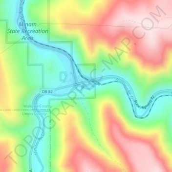
Name: Topografische Karte Big Canyon Fish Weir, Höhe, Relief.
Durchschnittliche Höhe: 944 m
Minimale Höhe: 762 m
Maximale Höhe: 1.157 m
Andere topografische Karten
Klicken Sie auf eine Karte, um ihre Topografie, ihre Höhe und ihr Relief anzuzeigen.
Enterprise
United States > Oregon > Wallowa County
Enterprise, Wallowa County, Oregon, United States
Durchschnittliche Höhe: 1.162 m
Troy
United States > Oregon > Wallowa County
Troy, Wallowa County, Oregon, United States
Durchschnittliche Höhe: 711 m
Eagle Cap Wilderness
United States > Oregon > Wallowa County
Eagle Cap Wilderness, Wallowa County, Oregon, United States
Durchschnittliche Höhe: 1.629 m
Imnaha
United States > Oregon > Wallowa County > Imnaha
Imnaha, Wallowa County, Oregon, 97842, United States
Durchschnittliche Höhe: 861 m
Wallowa
United States > Oregon > Wallowa County > Wallowa
Wallowa, Wallowa County, Oregon, 97885, United States
Durchschnittliche Höhe: 937 m
Joseph
United States > Oregon > Wallowa County
Joseph, Wallowa County, Oregon, 97846, United States
Durchschnittliche Höhe: 1.285 m