
Topografische Karte Κοιλάδα
Interaktive Karte
Klicken Sie auf die Karte, um die Höhe anzuzeigen.
Über diese Karte
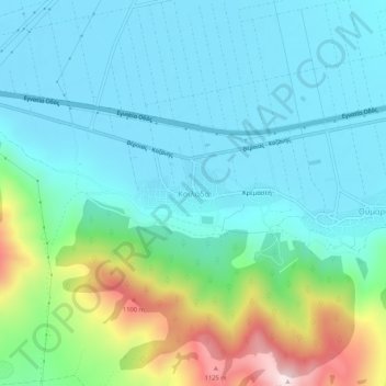
Name: Topografische Karte Κοιλάδα, Höhe, Relief.
Durchschnittliche Höhe: 779 m
Minimale Höhe: 650 m
Maximale Höhe: 1.229 m
Andere topografische Karten
Klicken Sie auf eine Karte, um ihre Topografie, ihre Höhe und ihr Relief anzuzeigen.
Ζαπάτιστα
Greece > Epirus and Western Macedonia > Kozani Regional Unit > Πεντάλοφος
Ζαπάτιστα, Πεντάλοφος, Voio Municipality, Kozani Regional Unit, Western Macedonia, Epirus and Western Macedonia, 500 07, Greece
Durchschnittliche Höhe: 1.085 m
Κοζάνη
Greece > Epirus and Western Macedonia > Kozani Regional Unit
Κοζάνη, Municipality of Kozani, Kozani Regional Unit, Western Macedonia, Epirus and Western Macedonia, 501 00, Greece
Durchschnittliche Höhe: 766 m
Ptolemaida
Greece > Epirus and Western Macedonia > Kozani Regional Unit
Ptolemaida, Eordaia Municipality, Kozani Regional Unit, Western Macedonia, Epirus and Western Macedonia, 502 00, Greece
Durchschnittliche Höhe: 621 m