
Topografische Karte Delaware County
Interaktive Karte
Klicken Sie auf die Karte, um die Höhe anzuzeigen.
Über diese Karte
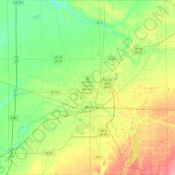
Name: Topografische Karte Delaware County, Höhe, Relief.
Ort: Delaware County, Indiana, United States (40.07639 -85.57880 40.37943 -85.21426)
Durchschnittliche Höhe: 288 m
Minimale Höhe: 257 m
Maximale Höhe: 343 m
Andere topografische Karten
Klicken Sie auf eine Karte, um ihre Topografie, ihre Höhe und ihr Relief anzuzeigen.
Drexel Gardens
United States > Indiana > Marion County > Indianapolis
Drexel Gardens, Indianapolis, Marion County, Indiana, 46241, United States
Durchschnittliche Höhe: 226 m
Greencastle
United States > Indiana > Putnam County > Greencastle
Greencastle, Putnam County, Indiana, 46135-1649, United States
Durchschnittliche Höhe: 235 m
Dyer
United States > Indiana > Lake County > Dyer
Dyer, Lake County, Indiana, 46311, United States
Durchschnittliche Höhe: 196 m
Madison County
Madison County, Indiana, United States
Durchschnittliche Höhe: 270 m