
Topografische Karte Hope Valley
Interaktive Karte
Klicken Sie auf die Karte, um die Höhe anzuzeigen.
Über diese Karte
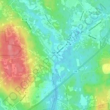
Name: Topografische Karte Hope Valley, Höhe, Relief.
Durchschnittliche Höhe: 54 m
Minimale Höhe: 21 m
Maximale Höhe: 116 m
Andere topografische Karten
Klicken Sie auf eine Karte, um ihre Topografie, ihre Höhe und ihr Relief anzuzeigen.
Ashaway
United States > Rhode Island > South County > Hopkinton > Ashaway
Ashaway, Hopkinton, South County, Rhode Island, 02804, United States
Durchschnittliche Höhe: 31 m
Ell Pond
United States > Rhode Island > South County > Hopkinton
Ell Pond, Hopkinton, South County, Rhode Island, United States
Durchschnittliche Höhe: 105 m
Hope Valley
United States > Rhode Island > South County > Hopkinton > Hope Valley
Hope Valley, Hopkinton, South County, Rhode Island, 02832, United States
Durchschnittliche Höhe: 55 m