
Spenden
Rüsten Sie sich für Ihr nächstes Abenteuer:
Als Amazon-Partner erhält diese Website eine Provision für qualifizierte Käufe, ohne zusätzliche Kosten für Sie.
Topografische Karte Phelps Corner
Klicken Sie auf die Karte, um die Höhe anzuzeigen.
Spenden
Rüsten Sie sich für Ihr nächstes Abenteuer:
Als Amazon-Partner erhält diese Website eine Provision für qualifizierte Käufe, ohne zusätzliche Kosten für Sie.
Über diese Karte
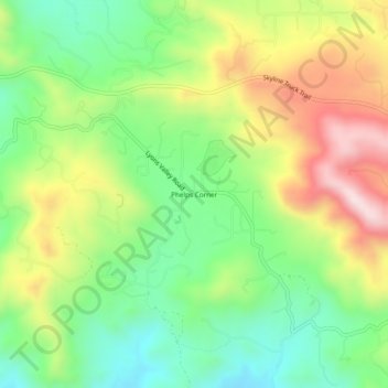
Name: Topografische Karte Phelps Corner, Höhe, Relief.
Ort: Phelps Corner, California, 91935, United States (32.70228 -116.83058 32.74228 -116.79058)
Durchschnittliche Höhe: 563 m
Minimale Höhe: 355 m
Maximale Höhe: 865 m
Spenden
Rüsten Sie sich für Ihr nächstes Abenteuer:
Als Amazon-Partner erhält diese Website eine Provision für qualifizierte Käufe, ohne zusätzliche Kosten für Sie.
Andere topografische Karten
Klicken Sie auf eine Karte, um ihre Topografie, ihre Höhe und ihr Relief anzuzeigen.
Lodi
United States > California > San Joaquin County
Lodi is flat terrain at an elevation of approximately 50 feet (15 m) above mean sea level datum. Historically, land in the area has been used for grazing as well as for grain production.
Durchschnittliche Höhe: 3 m
Big Bear Lake
United States > California > San Bernardino County > Big Bear Lake
At a surface elevation of 6,743 ft (2,055 m) above sea level, it has an east-west length of approximately seven miles (11 km) and is approximately 2.5 miles (4.0 km) at its widest measurement, though the lake's width mostly averages a little more than 1⁄2 mi (0.8 km). These approximations are based on the…
Durchschnittliche Höhe: 2.209 m
Twentynine Palms
United States > California > Twentynine Palms
According to the United States Census Bureau, the city has a total area of 59.1 square miles (153 km2), all land. The city is at an elevation of 1,988 feet (606 m). The Marine Corps Air Ground Combat Center Twentynine Palms is located there.
Durchschnittliche Höhe: 690 m
Kern River
Despite its remote source, nearly all of the river is publicly accessible. The Kern River is particularly popular for wilderness hiking and whitewater rafting. The Upper Kern River is paralleled by trails to within a half-mile of its source (which lies at 13,600 feet (4,100 m)). Even with the presence of Lake…
Durchschnittliche Höhe: 1.216 m
Spenden
Rüsten Sie sich für Ihr nächstes Abenteuer:
Als Amazon-Partner erhält diese Website eine Provision für qualifizierte Käufe, ohne zusätzliche Kosten für Sie.
Hopland
United States > California > Mendocino County > Hopland
Hopland (formerly Sanel) is a census-designated place in Mendocino County, California, United States. It is located on the west bank of the Russian River 13 miles (21 km) south-southeast of Ukiah, in the Sanel Valley, at an elevation of 502 feet (153 m). The population was 661 at the 2020 census, down from 756…
Durchschnittliche Höhe: 165 m
Annadel State Park
United States > California > Sonoma County > Santa Rosa
Durchschnittliche Höhe: 223 m
Los Padres National Forest
Los Padres National Forest is a United States national forest in southern and central California. Administered by the United States Forest Service, Los Padres includes most of the mountainous land along the California coast from Ventura to Monterey, extending inland. Elevations range from sea level to 8,847…
Durchschnittliche Höhe: 445 m
Spenden
Rüsten Sie sich für Ihr nächstes Abenteuer:
Als Amazon-Partner erhält diese Website eine Provision für qualifizierte Käufe, ohne zusätzliche Kosten für Sie.
Crescent City
United States > California > Del Norte County
The topography of the sea floor surrounding Crescent City has the effect of focusing tsunamis. According to researchers at Humboldt State University and the University of Southern California, the city experienced tsunami conditions 31 times between the years 1933 and 2008. Although many of these incidents were…
Durchschnittliche Höhe: 31 m
Spenden
Rüsten Sie sich für Ihr nächstes Abenteuer:
Als Amazon-Partner erhält diese Website eine Provision für qualifizierte Käufe, ohne zusätzliche Kosten für Sie.
Crestline
United States > California > San Bernardino County > Crestline
Durchschnittliche Höhe: 1.301 m
Avenal
United States > California > Kings County
Avenal (Spanish for "Oat field") is a city in Kings County, California, United States. Avenal is located 35 miles (56 km) southwest of Hanford, at an elevation of 807 ft (246 m). It is part of the Hanford–Corcoran Metropolitan Statistical Area (MSA Code 25260), which encompasses all of Kings County. In area,…
Durchschnittliche Höhe: 247 m
Gilroy
United States > California > Gilroy
Gilroy is located at 37°00′43″N 121°34′48″W / 37.012048°N 121.580080°W / 37.012048; -121.580080. It is approximately 26 km (16 mi) south of San Jose, California (Bailey Avenue (37.206770, -121.729150) to Monterey/Day Road (37.038210, -121.584480)) on U.S. Route 101 and 31 km (19 mi) inland…
Durchschnittliche Höhe: 106 m
Spenden
Rüsten Sie sich für Ihr nächstes Abenteuer:
Als Amazon-Partner erhält diese Website eine Provision für qualifizierte Käufe, ohne zusätzliche Kosten für Sie.
Palm Springs
United States > California > Riverside County
Palm Springs, located in the Coachella Valley, is characterized by striking topography shaped by both the Colorado Desert and surrounding mountain ranges. The city lies at an average elevation of around 480 feet (146 meters) above sea level. To the west, the San Bernardino Mountains rise dramatically, with…
Durchschnittliche Höhe: 859 m
Crystal Cove State Park
United States > California > Orange County > Newport Beach
Durchschnittliche Höhe: 155 m
Pacific Palisades
United States > California > Los Angeles County > Los Angeles
Pacific Palisades was formally founded in 1921 by a Methodist organization, and in the years that followed became a refuge for Jewish artists and intellectuals fleeing the Holocaust. The Palisades would later be sought after by celebrities and other high-profile individuals seeking privacy. It is known for its…
Durchschnittliche Höhe: 196 m
Clear Lake
United States > California > Lake County > Lakeport
Clear Lake is 19 mi (31 km) by 8 mi (13 km) at its widest point, with a surface area of 43,785 acres (17,719 ha) and a 1,155,000 acre⋅ft (1,425,000 dam3) capacity. Average depth is 27 ft (8.2 m), maximum is 60 ft (18 m), lake elevation is 1,329 ft (405 m), and average water temperature is 40 °F (4 °C) in…
Durchschnittliche Höhe: 531 m
Spenden
Rüsten Sie sich für Ihr nächstes Abenteuer:
Als Amazon-Partner erhält diese Website eine Provision für qualifizierte Käufe, ohne zusätzliche Kosten für Sie.
Runyon Canyon Park
United States > California > Los Angeles County > Los Angeles
Durchschnittliche Höhe: 235 m
Tuolumne Meadows
United States > California > Tuolumne County > Tuolumne Meadows
Durchschnittliche Höhe: 2.668 m
Spenden
Rüsten Sie sich für Ihr nächstes Abenteuer:
Als Amazon-Partner erhält diese Website eine Provision für qualifizierte Käufe, ohne zusätzliche Kosten für Sie.
Hemet
United States > California > Hemet
Dedicated to James Simpson, Hemet City Council 1947–48, and mayor 1950 to 1966. Simpson Park is a wilderness park located in the Santa Rosa Hills southeast of Hemet with sheltered picnic area and tables, barbecues, restrooms, and hiking trails. At an elevation of 2,500 feet (760 m), it provides an expansive…
Durchschnittliche Höhe: 508 m
Sierra National Forest
Sierra National Forest covers, in descending order of forestland area, the eastern portions of Fresno, Madera, and Mariposa counties, adjacent to the southern part of Yosemite National Park. It includes more than 1,300,000 acres (2,000 sq mi; 5,300 km2), at altitudes ranging from 900 to 13,986 feet (274 to…
Durchschnittliche Höhe: 1.987 m
Spenden
Rüsten Sie sich für Ihr nächstes Abenteuer:
Als Amazon-Partner erhält diese Website eine Provision für qualifizierte Käufe, ohne zusätzliche Kosten für Sie.
Pine Valley
According to the United States Geological Survey, Pine Valley is located 3,736 feet (1,139 m) above sea level, at 32°49′17″N 116°31′45″W / 32.82139°N 116.52917°W / 32.82139; -116.52917. Interstate 8 passes east-to-west along the southern border of Pine Valley. It crosses the Pine Valley…
Durchschnittliche Höhe: 1.291 m
Mojave National Preserve
Climate in the preserve varies greatly. Summer temperatures average 90 °F (32 °C), with highs exceeding 105 °F (41 °C). Elevations in the preserve range from 7,929 feet (2,417 m) at Clark Mountain to 880 feet (270 m) near Baker. Annual precipitation varies from 3.37 inches (86 mm) near Baker, to almost 9…
Durchschnittliche Höhe: 959 m
Spenden
Rüsten Sie sich für Ihr nächstes Abenteuer:
Als Amazon-Partner erhält diese Website eine Provision für qualifizierte Käufe, ohne zusätzliche Kosten für Sie.
Rancho Cordova
United States > California > Sacramento County
In the Gold Rush era of mid-19th-century California, certain Placer mining activities took place in the Rancho Cordova environs, some traces of which disturbance are extant. The elevation of the generally level terrain is approximately 118 feet (36 m) above mean sea level. Lone Star Gravel Company and other…
Durchschnittliche Höhe: 31 m
Lassen National Forest
An ancient volcano, known as Mount Tehama is believed to have been much larger and taller than Lassen Peak. Its erosion is responsible for the topography of the national forest and the national park: a volcanic rim, with elevations beginning at 6,000 feet (1,800 m) above sea level.
Durchschnittliche Höhe: 1.492 m
Anza-Borrego Desert State Park
Anza-Borrego Desert State Park lies in a unique geologic setting along the western margin of the Salton Trough. This major topographic depression with the Salton Sink having elevations of 200 ft (61 m) below sea level, forms the northernmost end of an active rift valley and a geological continental plate…
Durchschnittliche Höhe: 606 m
Hollywood Hills
United States > California > Los Angeles County > Los Angeles
Durchschnittliche Höhe: 242 m
Spenden
Rüsten Sie sich für Ihr nächstes Abenteuer:
Als Amazon-Partner erhält diese Website eine Provision für qualifizierte Käufe, ohne zusätzliche Kosten für Sie.
Independence
Independence is a census-designated place in Inyo County, California. Independence is located 41 miles (66 km) south-southeast of Bishop, at an elevation of 3930 feet (1198 m). It is the county seat of Inyo County, California. The population of this census-designated place was 669 at the 2010 census, up from…
Durchschnittliche Höhe: 1.199 m
Spenden
Rüsten Sie sich für Ihr nächstes Abenteuer:
Als Amazon-Partner erhält diese Website eine Provision für qualifizierte Käufe, ohne zusätzliche Kosten für Sie.
Spenden
Rüsten Sie sich für Ihr nächstes Abenteuer:
Als Amazon-Partner erhält diese Website eine Provision für qualifizierte Käufe, ohne zusätzliche Kosten für Sie.
Yucca Valley
United States > California > San Bernardino County
Yucca Valley lies in the middle of the Morongo Basin at a base elevation of 3,300 feet. Joshua Tree National Park is adjacent to its southern border.
Durchschnittliche Höhe: 1.106 m
Spenden
Rüsten Sie sich für Ihr nächstes Abenteuer:
Als Amazon-Partner erhält diese Website eine Provision für qualifizierte Käufe, ohne zusätzliche Kosten für Sie.
Spenden
Rüsten Sie sich für Ihr nächstes Abenteuer:
Als Amazon-Partner erhält diese Website eine Provision für qualifizierte Käufe, ohne zusätzliche Kosten für Sie.
Spenden
Rüsten Sie sich für Ihr nächstes Abenteuer:
Als Amazon-Partner erhält diese Website eine Provision für qualifizierte Käufe, ohne zusätzliche Kosten für Sie.
Idyllwild-Pine Cove
United States > California > Riverside County
"Mile-high Idyllwild" is a mountain resort about one-mile (1,600 m) in altitude. Idyllwild is flanked by two large rock formations, Tahquitz Peak and Suicide Rock (also known as Lily Rock), which are famous in Southern California rock-climbing circles. It offers no skiing, so "the Hill" has been minimally…
Durchschnittliche Höhe: 1.746 m
Fort Bragg
United States > California > Mendocino County
Fort Bragg, officially the City of Fort Bragg, is a city along the Pacific Coast of California along Shoreline Highway in Mendocino County. The city is 24 miles (39 km) west of Willits, at an elevation of 85 feet (26 m). Its population was 6,983 at the 2020 census.
Durchschnittliche Höhe: 8 m
Spenden
Rüsten Sie sich für Ihr nächstes Abenteuer:
Als Amazon-Partner erhält diese Website eine Provision für qualifizierte Käufe, ohne zusätzliche Kosten für Sie.
Humboldt Hill
United States > California > Humboldt County
Humboldt Hill is a census-designated place (CDP) in Humboldt County, California, United States. Humboldt Hill rises to an elevation of 636 feet (194 m). The population was 3,414 at the 2010 census, up from 3,246 at the 2000 census. The area is in the 95503 zip code and part of unincorporated Eureka.
Durchschnittliche Höhe: 45 m
Placerville
United States > California > Placerville
The region east of Placerville, popularly known as Apple Hill and Pleasant Valley, is becoming a center for wine production. The wine region is officially designated as the El Dorado AVA. The largest wineries in the area are Boeger, Lava Cap and Madrona, but most of the 30 plus wineries surrounding Placerville…
Durchschnittliche Höhe: 587 m
King City
United States > California > Monterey County
King City (variants: Kings City, City of King) is a city in Monterey County, California, United States. It is located on the Salinas River 51 miles (82 km) southeast of Salinas, at an elevation of 335 feet (102 m). It lies along U.S. Route 101 in the Salinas Valley of California's Central Coast. King City is a…
Durchschnittliche Höhe: 93 m
Spenden
Rüsten Sie sich für Ihr nächstes Abenteuer:
Als Amazon-Partner erhält diese Website eine Provision für qualifizierte Käufe, ohne zusätzliche Kosten für Sie.
Boyle Heights
United States > California > Los Angeles County > Los Angeles
Durchschnittliche Höhe: 91 m
Spenden
Rüsten Sie sich für Ihr nächstes Abenteuer:
Als Amazon-Partner erhält diese Website eine Provision für qualifizierte Käufe, ohne zusätzliche Kosten für Sie.
Newport Coast
United States > California > Orange County > Newport Beach
Durchschnittliche Höhe: 102 m
Spenden
Rüsten Sie sich für Ihr nächstes Abenteuer:
Als Amazon-Partner erhält diese Website eine Provision für qualifizierte Käufe, ohne zusätzliche Kosten für Sie.
Cascade Canyon Open Space Preserve
United States > California > Marin County > Fairfax > Manor
Durchschnittliche Höhe: 191 m
Spenden
Rüsten Sie sich für Ihr nächstes Abenteuer:
Als Amazon-Partner erhält diese Website eine Provision für qualifizierte Käufe, ohne zusätzliche Kosten für Sie.
Susanville
United States > California > Lassen County
Susanville (formerly known as Rooptown) is a town in and is the county seat of Lassen County, California, United States. Susanville is located on the Susan River in the southern part of the county, at an elevation of 4,186 feet (1,276 m). Its population is 16,728 as of the 2020 census, down from 17,947 from…
Durchschnittliche Höhe: 1.345 m
Thousand Oaks
United States > California > Ventura County > Thousand Oaks
The northern parts consist of mountainous terrain in the Simi Hills, Conejo Mountains and Mount Clef Ridge. Narrow canyons such as Hill Canyon cut through the steeper mountainous areas. Conejo Mountain and Conejo Grade are found in westernmost Newbury Park, while the southernmost parts of Thousand Oaks are…
Durchschnittliche Höhe: 303 m
Mammoth Lakes
United States > California > Mammoth Lakes
Mammoth Lakes is a town in Mono County, California, the county's only incorporated community. It is located immediately to the east of Mammoth Mountain, at an elevation of 7,880 feet (2,400 m). As of the 2010 United States Census, the population was 8,234, reflecting a 16% increase from the 2000 Census.
Durchschnittliche Höhe: 2.184 m
Spenden
Rüsten Sie sich für Ihr nächstes Abenteuer:
Als Amazon-Partner erhält diese Website eine Provision für qualifizierte Käufe, ohne zusätzliche Kosten für Sie.
Lancaster
United States > California > Lancaster
According to the United States Census Bureau, the city has a total area of 94.5 square miles (245 km2), of which 94.3 square miles (244 km2) is land and 0.3 square miles (0.78 km2) (0.29%) is water. Lancaster's elevation is 2,350 feet (720 m) above sea level on a high, flat valley surrounded by pristine…
Durchschnittliche Höhe: 787 m
Bermuda Dunes
United States > California > Riverside County > Palm Desert
According to the United States Census Bureau, the CDP has a total area of 2.9 square miles (7.5 km2), all of it land. The official elevation of Bermuda Dunes is 30 feet (9.1 m) above sea level, but the surface drops by over 80 feet (24 m) from west to east.
Durchschnittliche Höhe: 27 m
Spenden
Rüsten Sie sich für Ihr nächstes Abenteuer:
Als Amazon-Partner erhält diese Website eine Provision für qualifizierte Käufe, ohne zusätzliche Kosten für Sie.
Palm Desert
United States > California > Riverside County
The elevation (City hall) is 224 feet (68 m) above sea level. Elevations vary from the lower northern half once covered in sand dunes to the upper slope southern cove (300–900 feet or 91–274 metres) all the way to the ridgeline at 1,000 feet (over 300 meters). Palm Desert is located in the Coachella…
Durchschnittliche Höhe: 298 m
Corte Madera
United States > California > Marin County
Corte Madera (/ˈkɔːrtə məˈdɛrə/; Spanish for "Chop Wood") is an incorporated town in Marin County, California. Corte Madera is located 3.25 miles (5.2 km) south of San Rafael, at an elevation of 39 feet (12 m). The population was 10,222 at the 2020 census. The town was named after the Spanish…
Durchschnittliche Höhe: 52 m
Spenden
Rüsten Sie sich für Ihr nächstes Abenteuer:
Als Amazon-Partner erhält diese Website eine Provision für qualifizierte Käufe, ohne zusätzliche Kosten für Sie.
Lakeport
United States > California > Lake County
Lakeport is an incorporated city and the county seat of Lake County, California. This city is 125 miles (201 km) northwest of Sacramento. Lakeport is on the western shore of the county namesake, Clear Lake, at an elevation of 1,355 feet (413 m). The population was 5,026 at the 2020 census, up from 4,753 at the…
Durchschnittliche Höhe: 417 m
Spenden
Rüsten Sie sich für Ihr nächstes Abenteuer:
Als Amazon-Partner erhält diese Website eine Provision für qualifizierte Käufe, ohne zusätzliche Kosten für Sie.
Tranquillity
United States > California > Fresno County
Tranquillity is a census-designated place (CDP) in Fresno County, California, United States. It is located 10 miles (16 km) southeast of Mendota, at an elevation of 164 feet (50 m). The population was 799 at the 2010 census, down from 813 at the 2000 census. Tranquillity High School is the only high school in…
Durchschnittliche Höhe: 49 m
Spenden
Rüsten Sie sich für Ihr nächstes Abenteuer:
Als Amazon-Partner erhält diese Website eine Provision für qualifizierte Käufe, ohne zusätzliche Kosten für Sie.
Raisin City
United States > California > Fresno County
Raisin City (formerly, Raisin) is a census-designated place (CDP) in Fresno County, California, United States. The population was 380 at the 2010 census, up from 165 at the 2000 census. Raisin City is located 13 miles (21 km) south-southwest of downtown Fresno, at an elevation of 236 feet (72 m).
Durchschnittliche Höhe: 73 m
San Gabriel River
United States > California > Los Angeles County > Pico Rivera
Durchschnittliche Höhe: 89 m
Decker Canyon Camp
United States > California > Los Angeles County > Malibu
Durchschnittliche Höhe: 385 m
Spenden
Rüsten Sie sich für Ihr nächstes Abenteuer:
Als Amazon-Partner erhält diese Website eine Provision für qualifizierte Käufe, ohne zusätzliche Kosten für Sie.