
Topografische Karte Villers-sur-Coudun
Interaktive Karte
Klicken Sie auf die Karte, um die Höhe anzuzeigen.
Über diese Karte
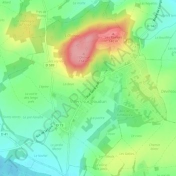
Name: Topografische Karte Villers-sur-Coudun, Höhe, Relief.
Durchschnittliche Höhe: 83 m
Minimale Höhe: 40 m
Maximale Höhe: 155 m
Le village est situé à flanc de colline appelée l'épine de Flavy dont le sommet culmine à environ 143 m d'altitude. Il est entouré par Coudun, Giraumont, Vignemont, Vandelicourt et Marest-sur-Matz. Il est situé à 12 km de Compiègne.
Andere topografische Karten
Klicken Sie auf eine Karte, um ihre Topografie, ihre Höhe und ihr Relief anzuzeigen.
Rully
France > Hauts-de-France > Oise
Rully, Senlis, Oise, Hauts-de-France, France métropolitaine, 60810, France
Durchschnittliche Höhe: 98 m
Godenvillers
France > Hauts-de-France > Oise
Godenvillers, Clermont, Oise, Hauts-de-France, France métropolitaine, 60420, France
Durchschnittliche Höhe: 98 m
Grez
France > Hauts-de-France > Oise
Grez, Beauvais, Oise, Hauts-de-France, France métropolitaine, 60210, France
Durchschnittliche Höhe: 185 m
Ferrières
France > Hauts-de-France > Oise
Ferrières, Clermont, Oise, Hauts-de-France, France métropolitaine, 60420, France
Durchschnittliche Höhe: 115 m
Montreuil-sur-Brêche
France > Hauts-de-France > Oise
Montreuil-sur-Brêche, Clermont, Oise, Hauts-de-France, France métropolitaine, 60480, France
Durchschnittliche Höhe: 137 m
Domfront
France > Hauts-de-France > Oise
Domfront, Clermont, Oise, Hauts-de-France, France métropolitaine, 60420, France
Durchschnittliche Höhe: 89 m
Herchies
France > Hauts-de-France > Oise
Herchies, Beauvais, Oise, Hauts-de-France, France métropolitaine, 60112, France
Durchschnittliche Höhe: 106 m
Bury
France > Hauts-de-France > Oise
Bury, Clermont, Oise, Hauts-de-France, France métropolitaine, 60250, France
Durchschnittliche Höhe: 80 m
Fontaine Saint Leu
France > Hauts-de-France > Oise > Boubiers
Fontaine Saint Leu, Chemin de Boubiers, Boubiers, Beauvais, Oise, Hauts-de-France, France métropolitaine, 60240, France
Durchschnittliche Höhe: 117 m
Beaurepaire
France > Hauts-de-France > Oise > Beaurepaire
Beaurepaire, Senlis, Oise, Hauts-de-France, France métropolitaine, 60700, France
Durchschnittliche Höhe: 68 m
Chaumont-en-Vexin
France > Hauts-de-France > Oise > Chaumont-en-Vexin
Chaumont-en-Vexin, Beauvais, Oise, Hauts-de-France, France métropolitaine, 60240, France
Durchschnittliche Höhe: 94 m
Maignelay-Montigny
France > Hauts-de-France > Oise
Maignelay-Montigny, Clermont, Oise, Hauts-de-France, France métropolitaine, 60420, France
Durchschnittliche Höhe: 117 m