
Topografische Karte Lost Nation
Interaktive Karte
Klicken Sie auf die Karte, um die Höhe anzuzeigen.
Über diese Karte
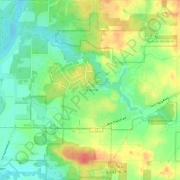
Name: Topografische Karte Lost Nation, Höhe, Relief.
Durchschnittliche Höhe: 223 m
Minimale Höhe: 198 m
Maximale Höhe: 256 m
Andere topografische Karten
Klicken Sie auf eine Karte, um ihre Topografie, ihre Höhe und ihr Relief anzuzeigen.
Grand Detour
United States > Illinois > Ogle County
Grand Detour, Grand Detour Township, Ogle County, Illinois, United States
Durchschnittliche Höhe: 213 m
Oregon
United States > Illinois > Ogle County
Oregon, Oregon - Nashua Township, Ogle County, Illinois, 61061, United States
Durchschnittliche Höhe: 223 m
Stillman Valley
United States > Illinois > Ogle County
Stillman Valley, Marion Township, Ogle County, Illinois, United States
Durchschnittliche Höhe: 222 m
Rockvale Township
United States > Illinois > Ogle County
Rockvale Township, Ogle County, Illinois, United States
Durchschnittliche Höhe: 239 m
Leaf River
United States > Illinois > Ogle County
Leaf River, Leaf River Township, Ogle County, Illinois, United States
Durchschnittliche Höhe: 227 m
Monroe Township
United States > Illinois > Ogle County
Monroe Township, Ogle County, Illinois, 61052, United States
Durchschnittliche Höhe: 243 m
Byron
United States > Illinois > Ogle County > Byron
Byron, Ogle County, Illinois, 61010, United States
Durchschnittliche Höhe: 226 m
Monroe Center
United States > Illinois > Ogle County
Monroe Center, Monroe Township, Ogle County, Illinois, United States
Durchschnittliche Höhe: 254 m
Rochelle
United States > Illinois > Ogle County
Rochelle, Flagg Township, Ogle County, Illinois, 61068, United States
Durchschnittliche Höhe: 243 m