
Topografische Karte Multnomah County
Interaktive Karte
Klicken Sie auf die Karte, um die Höhe anzuzeigen.
Über diese Karte
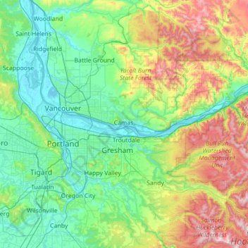
Name: Topografische Karte Multnomah County, Höhe, Relief.
Ort: Multnomah County, Oregon, United States of America (45.43263 -122.92921 45.72864 -121.81967)
Durchschnittliche Höhe: 334 m
Minimale Höhe: -2 m
Maximale Höhe: 1.519 m
Andere topografische Karten
Klicken Sie auf eine Karte, um ihre Topografie, ihre Höhe und ihr Relief anzuzeigen.
Hillsboro
United States of America > Oregon > Hillsboro
Hillsboro, Washington County, Oregon, United States of America
Durchschnittliche Höhe: 53 m
Tillamook County
United States of America > Oregon
Tillamook County, Oregon, United States of America
Durchschnittliche Höhe: 236 m
Clackamas County
United States of America > Oregon
Clackamas County, Oregon, United States of America
Durchschnittliche Höhe: 660 m
Coos County
United States of America > Oregon
Coos County, Oregon, United States of America
Durchschnittliche Höhe: 266 m