
Spenden
Rüsten Sie sich für Ihr nächstes Abenteuer:
Als Amazon-Partner erhält diese Website eine Provision für qualifizierte Käufe, ohne zusätzliche Kosten für Sie.
Topografische Karte Wasaga Beach
Klicken Sie auf die Karte, um die Höhe anzuzeigen.
Spenden
Rüsten Sie sich für Ihr nächstes Abenteuer:
Als Amazon-Partner erhält diese Website eine Provision für qualifizierte Käufe, ohne zusätzliche Kosten für Sie.
Wasaga Beach
The Town of Wasaga Beach covers an area of 61.13 square kilometres (23.60 sq mi) comprised predominantly of sand and loamy sand that exhibit excessive to good drainage and irregular to moderately sloping topography. The poor soil quality makes it difficult to sustain lush lawns in the town. The Canada Land Inventory for Agriculture rates the lands as predominately Class Six and Seven with primary restrictions of adverse topography, erosion damage and low natural fertility.
Spenden
Rüsten Sie sich für Ihr nächstes Abenteuer:
Als Amazon-Partner erhält diese Website eine Provision für qualifizierte Käufe, ohne zusätzliche Kosten für Sie.
Über diese Karte
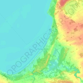
Name: Topografische Karte Wasaga Beach, Höhe, Relief.
Durchschnittliche Höhe: 190 m
Minimale Höhe: 173 m
Maximale Höhe: 237 m
Spenden
Rüsten Sie sich für Ihr nächstes Abenteuer:
Als Amazon-Partner erhält diese Website eine Provision für qualifizierte Käufe, ohne zusätzliche Kosten für Sie.
Andere topografische Karten
Klicken Sie auf eine Karte, um ihre Topografie, ihre Höhe und ihr Relief anzuzeigen.
Spenden
Rüsten Sie sich für Ihr nächstes Abenteuer:
Als Amazon-Partner erhält diese Website eine Provision für qualifizierte Käufe, ohne zusätzliche Kosten für Sie.
Waubashene Beaches Provincial Park
Canada > Ontario > Simcoe County > Tay > Waubaushene
Durchschnittliche Höhe: 189 m
Spenden
Rüsten Sie sich für Ihr nächstes Abenteuer:
Als Amazon-Partner erhält diese Website eine Provision für qualifizierte Käufe, ohne zusätzliche Kosten für Sie.
Spenden
Rüsten Sie sich für Ihr nächstes Abenteuer:
Als Amazon-Partner erhält diese Website eine Provision für qualifizierte Käufe, ohne zusätzliche Kosten für Sie.
Noisy River Provincial Park
Canada > Ontario > Simcoe County > Clearview
Durchschnittliche Höhe: 467 m
Spenden
Rüsten Sie sich für Ihr nächstes Abenteuer:
Als Amazon-Partner erhält diese Website eine Provision für qualifizierte Käufe, ohne zusätzliche Kosten für Sie.
Beckwith Island
Canada > Ontario > Simcoe County
The island's highest elevation is 226 meters (741 feet) above sea level. Like its populated neighbour Christian Island to the west, and Hope Island to the northwest, the uninhabited island is part of an Ojibwa reserve. On the mainland, Cedar Point lies directly south of the island and Thunder Beach is located…
Durchschnittliche Höhe: 185 m
Spenden
Rüsten Sie sich für Ihr nächstes Abenteuer:
Als Amazon-Partner erhält diese Website eine Provision für qualifizierte Käufe, ohne zusätzliche Kosten für Sie.
Penatanguishene Memorial Park
Canada > Ontario > Simcoe County > Penetanguishene
Durchschnittliche Höhe: 210 m
Spenden
Rüsten Sie sich für Ihr nächstes Abenteuer:
Als Amazon-Partner erhält diese Website eine Provision für qualifizierte Käufe, ohne zusätzliche Kosten für Sie.
Spenden
Rüsten Sie sich für Ihr nächstes Abenteuer:
Als Amazon-Partner erhält diese Website eine Provision für qualifizierte Käufe, ohne zusätzliche Kosten für Sie.
Spenden
Rüsten Sie sich für Ihr nächstes Abenteuer:
Als Amazon-Partner erhält diese Website eine Provision für qualifizierte Käufe, ohne zusätzliche Kosten für Sie.
Spenden
Rüsten Sie sich für Ihr nächstes Abenteuer:
Als Amazon-Partner erhält diese Website eine Provision für qualifizierte Käufe, ohne zusätzliche Kosten für Sie.
Spenden
Rüsten Sie sich für Ihr nächstes Abenteuer:
Als Amazon-Partner erhält diese Website eine Provision für qualifizierte Käufe, ohne zusätzliche Kosten für Sie.
Taylor Park
Canada > Ontario > Simcoe County > Bradford West Gwillimbury
Durchschnittliche Höhe: 229 m
Spenden
Rüsten Sie sich für Ihr nächstes Abenteuer:
Als Amazon-Partner erhält diese Website eine Provision für qualifizierte Käufe, ohne zusätzliche Kosten für Sie.
Edenvale Conservation Area
Canada > Ontario > Simcoe County > Springwater
Durchschnittliche Höhe: 193 m
Spenden
Rüsten Sie sich für Ihr nächstes Abenteuer:
Als Amazon-Partner erhält diese Website eine Provision für qualifizierte Käufe, ohne zusätzliche Kosten für Sie.
Spenden
Rüsten Sie sich für Ihr nächstes Abenteuer:
Als Amazon-Partner erhält diese Website eine Provision für qualifizierte Käufe, ohne zusätzliche Kosten für Sie.
West Holland River (old)
Canada > Ontario > Simcoe County > Bradford West Gwillimbury
Durchschnittliche Höhe: 222 m
Friday Harbour Nature Preserve
Canada > Ontario > Simcoe County > Innisfil
Durchschnittliche Höhe: 230 m
Spenden
Rüsten Sie sich für Ihr nächstes Abenteuer:
Als Amazon-Partner erhält diese Website eine Provision für qualifizierte Käufe, ohne zusätzliche Kosten für Sie.
Mara Provincial Park
Canada > Ontario > Simcoe County > Ramara Township > Atherley
Durchschnittliche Höhe: 220 m
Spenden
Rüsten Sie sich für Ihr nächstes Abenteuer:
Als Amazon-Partner erhält diese Website eine Provision für qualifizierte Käufe, ohne zusätzliche Kosten für Sie.
Wasaga Beach Provincial Park
Canada > Ontario > Simcoe County > Wasaga Beach
The Town of Wasaga Beach covers an area of 61.13 square kilometres (23.60 sq mi) comprised predominantly of sand and loamy sand that exhibit excessive to good drainage and irregular to moderately sloping topography. The poor soil quality makes it difficult to sustain lush lawns in the town. The Canada Land…
Durchschnittliche Höhe: 188 m
Spenden
Rüsten Sie sich für Ihr nächstes Abenteuer:
Als Amazon-Partner erhält diese Website eine Provision für qualifizierte Käufe, ohne zusätzliche Kosten für Sie.
Springhurst Beach
Canada > Ontario > Simcoe County > Wasaga Beach > Springhurst Beach
Durchschnittliche Höhe: 184 m