
Spenden
Rüsten Sie sich für Ihr nächstes Abenteuer:
Als Amazon-Partner erhält diese Website eine Provision für qualifizierte Käufe, ohne zusätzliche Kosten für Sie.
Topografische Karte Queenborough
Klicken Sie auf die Karte, um die Höhe anzuzeigen.
Spenden
Rüsten Sie sich für Ihr nächstes Abenteuer:
Als Amazon-Partner erhält diese Website eine Provision für qualifizierte Käufe, ohne zusätzliche Kosten für Sie.
Über diese Karte
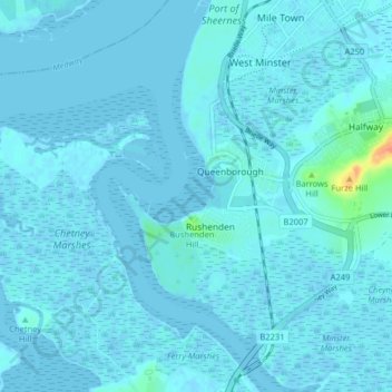
Name: Topografische Karte Queenborough, Höhe, Relief.
Ort: Queenborough, Borough of Swale, Kent, England, United Kingdom (51.39019 0.69194 51.43479 0.77219)
Durchschnittliche Höhe: 2 m
Minimale Höhe: -4 m
Maximale Höhe: 40 m
Spenden
Rüsten Sie sich für Ihr nächstes Abenteuer:
Als Amazon-Partner erhält diese Website eine Provision für qualifizierte Käufe, ohne zusätzliche Kosten für Sie.
Andere topografische Karten
Klicken Sie auf eine Karte, um ihre Topografie, ihre Höhe und ihr Relief anzuzeigen.
Spenden
Rüsten Sie sich für Ihr nächstes Abenteuer:
Als Amazon-Partner erhält diese Website eine Provision für qualifizierte Käufe, ohne zusätzliche Kosten für Sie.
Lower Hartlip
United Kingdom > England > Kent > Borough of Swale > Hartlip
Durchschnittliche Höhe: 55 m
Spenden
Rüsten Sie sich für Ihr nächstes Abenteuer:
Als Amazon-Partner erhält diese Website eine Provision für qualifizierte Käufe, ohne zusätzliche Kosten für Sie.
Berryfield
United Kingdom > England > Kent > Borough of Swale > Eastchurch
Durchschnittliche Höhe: 22 m
Spenden
Rüsten Sie sich für Ihr nächstes Abenteuer:
Als Amazon-Partner erhält diese Website eine Provision für qualifizierte Käufe, ohne zusätzliche Kosten für Sie.
Spenden
Rüsten Sie sich für Ihr nächstes Abenteuer:
Als Amazon-Partner erhält diese Website eine Provision für qualifizierte Käufe, ohne zusätzliche Kosten für Sie.
Berryfield
United Kingdom > England > Kent > Borough of Swale > Eastchurch
Durchschnittliche Höhe: 22 m
Spenden
Rüsten Sie sich für Ihr nächstes Abenteuer:
Als Amazon-Partner erhält diese Website eine Provision für qualifizierte Käufe, ohne zusätzliche Kosten für Sie.
Oare Creek
United Kingdom > England > Kent > Borough of Swale > Faversham > Oare
Durchschnittliche Höhe: 6 m
Spenden
Rüsten Sie sich für Ihr nächstes Abenteuer:
Als Amazon-Partner erhält diese Website eine Provision für qualifizierte Käufe, ohne zusätzliche Kosten für Sie.
Hickmans Green
United Kingdom > England > Kent > Borough of Swale > Boughton Street
Durchschnittliche Höhe: 63 m
Faversham Creek
United Kingdom > England > Kent > Borough of Swale > Faversham > Oare
Durchschnittliche Höhe: 11 m
Great Norwood
United Kingdom > England > Kent > Borough of Swale > Bobbing
Durchschnittliche Höhe: 27 m
Spenden
Rüsten Sie sich für Ihr nächstes Abenteuer:
Als Amazon-Partner erhält diese Website eine Provision für qualifizierte Käufe, ohne zusätzliche Kosten für Sie.
Faversham Creek
United Kingdom > England > Kent > Borough of Swale > Faversham > Oare
Durchschnittliche Höhe: 8 m
Lewson Street
United Kingdom > England > Kent > Borough of Swale > Norton
Durchschnittliche Höhe: 36 m
Rodmersham Green
United Kingdom > England > Kent > Borough of Swale > Rodmersham Green
Durchschnittliche Höhe: 48 m
Spenden
Rüsten Sie sich für Ihr nächstes Abenteuer:
Als Amazon-Partner erhält diese Website eine Provision für qualifizierte Käufe, ohne zusätzliche Kosten für Sie.
Whitehill
United Kingdom > England > Kent > Borough of Swale > Painter's Forstal
Durchschnittliche Höhe: 45 m