
Topografische Karte Florence
Interaktive Karte
Klicken Sie auf die Karte, um die Höhe anzuzeigen.
Über diese Karte
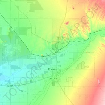
Name: Topografische Karte Florence, Höhe, Relief.
Ort: Florence, Pinal County, Arizona, 85132, United States (32.98666 -111.51639 33.13299 -111.30103)
Durchschnittliche Höhe: 484 m
Minimale Höhe: 426 m
Maximale Höhe: 597 m
Andere topografische Karten
Klicken Sie auf eine Karte, um ihre Topografie, ihre Höhe und ihr Relief anzuzeigen.
Kelvin
United States > Arizona > Pinal County
Kelvin, Pinal County, Arizona, 85137, United States
Durchschnittliche Höhe: 626 m
Eloy
United States > Arizona > Pinal County
Eloy, Pinal County, Arizona, United States
Durchschnittliche Höhe: 478 m
Gold Canyon
United States > Arizona > Pinal County > Apache Junction
Gold Canyon, Apache Junction, Pinal County, Arizona, 85218, United States
Durchschnittliche Höhe: 675 m
Heaton
United States > Arizona > Pinal County > Maricopa
Heaton, Maricopa, Pinal County, Arizona, United States
Durchschnittliche Höhe: 367 m
Apache Junction
United States > Arizona > Pinal County
Apache Junction, Pinal County, Arizona, United States
Durchschnittliche Höhe: 504 m
Maricopa
United States > Arizona > Pinal County
Maricopa, Pinal County, Arizona, United States
Durchschnittliche Höhe: 369 m
Coolidge
United States > Arizona > Pinal County
Coolidge, Pinal County, Arizona, United States
Durchschnittliche Höhe: 439 m
Mammoth
United States > Arizona > Pinal County
Mammoth, Pinal County, Arizona, 85618, United States
Durchschnittliche Höhe: 756 m
Casa Grande
United States > Arizona > Pinal County
Casa Grande, Pinal County, Arizona, United States
Durchschnittliche Höhe: 437 m