
Topografische Karte Malpasset
Interaktive Karte
Klicken Sie auf die Karte, um die Höhe anzuzeigen.
Über diese Karte
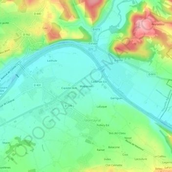
Name: Topografische Karte Malpasset, Höhe, Relief.
Durchschnittliche Höhe: 104 m
Minimale Höhe: 58 m
Maximale Höhe: 204 m
Andere topografische Karten
Klicken Sie auf eine Karte, um ihre Topografie, ihre Höhe und ihr Relief anzuzeigen.
Index
France > Nouvelle-Aquitaine > Lot-et-Garonne > Montayral
Index, Montayral, Villeneuve-sur-Lot, Lot-et-Garonne, Nouvelle-Aquitaine, France métropolitaine, 47500, France
Durchschnittliche Höhe: 125 m
Péluzac
France > Nouvelle-Aquitaine > Lot-et-Garonne > Montayral
Péluzac, Montayral, Villeneuve-sur-Lot, Lot-et-Garonne, Nouvelle-Aquitaine, France métropolitaine, 47500, France
Durchschnittliche Höhe: 99 m