
Topografische Karte St Albans
Interaktive Karte
Klicken Sie auf die Karte, um die Höhe anzuzeigen.
Über diese Karte
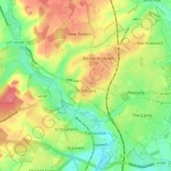
Name: Topografische Karte St Albans, Höhe, Relief.
Ort: St Albans, Hertfordshire, England, United Kingdom (51.72913 -0.37529 51.78007 -0.29102)
Durchschnittliche Höhe: 103 m
Minimale Höhe: 69 m
Maximale Höhe: 141 m
The borough consisted of the ancient parish of St Albans (also known as the Abbey parish) and parts of the parishes of St Michael and St Peter. The borough was reformed by the Municipal Corporations Act 1835 to become a municipal borough, and the boundary was adjusted to additionally include part of the parish of St Stephen. On 28 August 1877 the borough gained city status, following the elevation of St Albans Abbey to become a cathedral. The boundary was also adjusted in 1877 to include part of the parish of Sandridge.
Andere topografische Karten
Klicken Sie auf eine Karte, um ihre Topografie, ihre Höhe und ihr Relief anzuzeigen.
Newnham
United Kingdom > England > Hertfordshire > North Hertfordshire
Newnham, North Hertfordshire, Hertfordshire, England, United Kingdom
Durchschnittliche Höhe: 69 m
Sandridge
United Kingdom > England > Hertfordshire > St Albans
Sandridge, St Albans, Hertfordshire, England, United Kingdom
Durchschnittliche Höhe: 105 m
Borehamwood
United Kingdom > England > Hertfordshire > Hertsmere
Borehamwood, Hertsmere, Hertfordshire, England, WD6 5HL, United Kingdom
Durchschnittliche Höhe: 104 m
Sandon
United Kingdom > England > Hertfordshire > North Hertfordshire
Sandon, North Hertfordshire, Hertfordshire, England, United Kingdom
Durchschnittliche Höhe: 130 m
Frogmore
United Kingdom > England > Hertfordshire > St Albans
Frogmore, St Albans, Hertfordshire, England, AL2 2LS, United Kingdom
Durchschnittliche Höhe: 80 m
Harpenden
United Kingdom > England > Hertfordshire > St Albans > Harpenden
Harpenden, St Albans, Hertfordshire, England, United Kingdom
Durchschnittliche Höhe: 119 m
Dacorum
United Kingdom > England > Hertfordshire > Dacorum
Dacorum, Hertfordshire, East of England, England, United Kingdom
Durchschnittliche Höhe: 142 m
Kings Langley
United Kingdom > England > Hertfordshire > Dacorum
Kings Langley, Dacorum, Hertfordshire, England, United Kingdom
Durchschnittliche Höhe: 111 m
Garston
United Kingdom > England > Hertfordshire > Watford > Garston
Garston, Watford, Hertfordshire, East of England, England, WD25 9JT, United Kingdom
Durchschnittliche Höhe: 83 m
Potters Bar
United Kingdom > England > Hertfordshire > Hertsmere
Potters Bar, Hertsmere, Hertfordshire, England, EN6 1QG, United Kingdom
Durchschnittliche Höhe: 98 m
Bishop's Stortford
United Kingdom > England > Hertfordshire > East Hertfordshire
Bishop's Stortford, East Hertfordshire, Hertfordshire, England, United Kingdom
Durchschnittliche Höhe: 83 m
St Albans
United Kingdom > England > Hertfordshire > St Albans
St Albans, Hertfordshire, East of England, England, United Kingdom
Durchschnittliche Höhe: 107 m
Hoddesdon
United Kingdom > England > Hertfordshire
Hoddesdon, Broxbourne, Hertfordshire, England, EN11 8UD, United Kingdom
Durchschnittliche Höhe: 54 m
Gilston
United Kingdom > England > Hertfordshire > East Hertfordshire > Gilston
Gilston, East Hertfordshire, Hertfordshire, England, United Kingdom
Durchschnittliche Höhe: 59 m
Wakeley
United Kingdom > England > Hertfordshire > East Hertfordshire > Buntingford > Westmill > Wakeley
Wakeley, Westmill, Buntingford, East Hertfordshire, Hertfordshire, East of England, England, SG9 9NH, United Kingdom
Durchschnittliche Höhe: 121 m