
Topografische Karte Waring
Interaktive Karte
Klicken Sie auf die Karte, um die Höhe anzuzeigen.
Über diese Karte
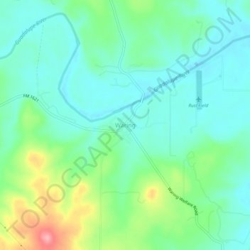
Name: Topografische Karte Waring, Höhe, Relief.
Ort: Waring, Kendall County, Texas, 78074, United States (29.93144 -98.82421 29.97144 -98.78421)
Durchschnittliche Höhe: 425 m
Minimale Höhe: 394 m
Maximale Höhe: 509 m
Andere topografische Karten
Klicken Sie auf eine Karte, um ihre Topografie, ihre Höhe und ihr Relief anzuzeigen.
Boerne
United States > Texas > Kendall County
Boerne, Kendall County, Texas, United States
Durchschnittliche Höhe: 465 m
Walnut Grove
United States > Texas > Kendall County
Walnut Grove, Kendall County, Texas, United States
Durchschnittliche Höhe: 455 m
Kreutzberg
United States > Texas > Kendall County
Kreutzberg, Kendall County, Texas, United States
Durchschnittliche Höhe: 426 m
Boerne
United States > Texas > Kendall County
Boerne, Kendall County, Texas, United States
Durchschnittliche Höhe: 465 m
Bergheim
United States > Texas > Kendall County
Bergheim, Kendall County, Texas, 78004, United States
Durchschnittliche Höhe: 419 m
Comfort
United States > Texas > Kendall County
Comfort, Kendall County, Texas, 70813, United States
Durchschnittliche Höhe: 457 m
Nelson City
United States > Texas > Kendall County
Nelson City, Kendall County, Texas, United States
Durchschnittliche Höhe: 485 m