
Topografische Karte State of Georgia
Interaktive Karte
Klicken Sie auf die Karte, um die Höhe anzuzeigen.
Über diese Karte
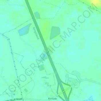
Name: Topografische Karte State of Georgia, Höhe, Relief.
Ort: State of Georgia, Camden County, Georgia, United States (30.85623 -81.67740 30.85885 -81.67526)
Durchschnittliche Höhe: 6 m
Minimale Höhe: -1 m
Maximale Höhe: 16 m
Andere topografische Karten
Klicken Sie auf eine Karte, um ihre Topografie, ihre Höhe und ihr Relief anzuzeigen.
Mount Storm
United States > Georgia > Camden County
Mount Storm, Camden County, Georgia, 31548, United States
Durchschnittliche Höhe: 7 m
Beach Creek
United States > Georgia > Camden County > Dungeness
Beach Creek, Dungeness, Camden County, Georgia, United States
Durchschnittliche Höhe: 1 m
Cumberland Island National Seashore
United States > Georgia > Camden County > St. Marys
Cumberland Island National Seashore, St. Marys, Camden County, Georgia, United States
Durchschnittliche Höhe: 1 m
St. Marys
United States > Georgia > Camden County > St. Marys
St. Marys, Camden County, Georgia, United States
Durchschnittliche Höhe: 3 m
Kingsland
United States > Georgia > Camden County > Kingsland
Kingsland, Camden County, Georgia, 31548, United States
Durchschnittliche Höhe: 6 m
Kingsland
United States > Georgia > Camden County
Kingsland, Camden County, Georgia, 31548, United States
Durchschnittliche Höhe: 5 m