
Spenden
Rüsten Sie sich für Ihr nächstes Abenteuer:
Als Amazon-Partner erhält diese Website eine Provision für qualifizierte Käufe, ohne zusätzliche Kosten für Sie.
Topografische Karte Colne
Klicken Sie auf die Karte, um die Höhe anzuzeigen.
Spenden
Rüsten Sie sich für Ihr nächstes Abenteuer:
Als Amazon-Partner erhält diese Website eine Provision für qualifizierte Käufe, ohne zusätzliche Kosten für Sie.
Colne
Pendle Leisure Trust runs the Pendle Leisure Centre next to the railway station. The facility has two swimming pools, a fitness centre and gymnasium, sauna and sports hall. In summer 2013, the outdoor all-weather pitch was replaced by Urban Altitude. This outdoor aerial assault course is the first of its kind to be built in the UK in an urban location. It includes high and low rope courses, up to 42 ft off the ground, a 60m Zip-Wire, Leap of Faith, Power Fan Free-fall, Jacobs Ladder and Climbing Wall.
Spenden
Rüsten Sie sich für Ihr nächstes Abenteuer:
Als Amazon-Partner erhält diese Website eine Provision für qualifizierte Käufe, ohne zusätzliche Kosten für Sie.
Über diese Karte
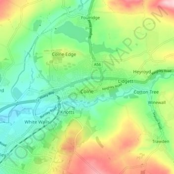
Name: Topografische Karte Colne, Höhe, Relief.
Ort: Colne, Borough of Pendle, Lancashire, England, United Kingdom (53.84131 -2.20491 53.87446 -2.12707)
Durchschnittliche Höhe: 197 m
Minimale Höhe: 122 m
Maximale Höhe: 328 m
Spenden
Rüsten Sie sich für Ihr nächstes Abenteuer:
Als Amazon-Partner erhält diese Website eine Provision für qualifizierte Käufe, ohne zusätzliche Kosten für Sie.
Andere topografische Karten
Klicken Sie auf eine Karte, um ihre Topografie, ihre Höhe und ihr Relief anzuzeigen.