
Topografische Karte Stadhampton
Interaktive Karte
Klicken Sie auf die Karte, um die Höhe anzuzeigen.
Über diese Karte
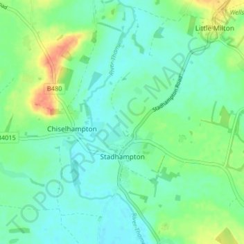
Name: Topografische Karte Stadhampton, Höhe, Relief.
Durchschnittliche Höhe: 61 m
Minimale Höhe: 48 m
Maximale Höhe: 90 m
Andere topografische Karten
Klicken Sie auf eine Karte, um ihre Topografie, ihre Höhe und ihr Relief anzuzeigen.
Didcot
United Kingdom > England > Oxfordshire > South Oxfordshire > East Hagbourne
Didcot, East Hagbourne, South Oxfordshire, Oxfordshire, England, United Kingdom
Durchschnittliche Höhe: 61 m
Wheatley
United Kingdom > England > Oxfordshire > South Oxfordshire
Wheatley, South Oxfordshire, Oxfordshire, England, United Kingdom
Durchschnittliche Höhe: 90 m
Thame
United Kingdom > England > Oxfordshire > South Oxfordshire
Thame, South Oxfordshire, Oxfordshire, England, United Kingdom
Durchschnittliche Höhe: 74 m