
Topografische Karte Astypalaia
Interaktive Karte
Klicken Sie auf die Karte, um die Höhe anzuzeigen.
Über diese Karte
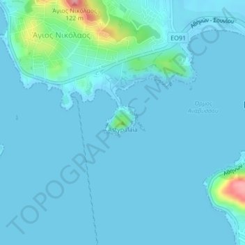
Name: Topografische Karte Astypalaia, Höhe, Relief.
Durchschnittliche Höhe: 10 m
Minimale Höhe: -2 m
Maximale Höhe: 114 m
Andere topografische Karten
Klicken Sie auf eine Karte, um ihre Topografie, ihre Höhe und ihr Relief anzuzeigen.
Ανάβυσσος
Greece > Attica > Regional Unit of East Attica > Anavissos Municipal Unit
Ανάβυσσος, Anavissos Municipal Unit, Municipality of Saronikos, Regional Unit of East Attica, Attica, 190 13, Greece
Durchschnittliche Höhe: 91 m