
Topografische Karte Wakefield
Interaktive Karte
Klicken Sie auf die Karte, um die Höhe anzuzeigen.
Über diese Karte
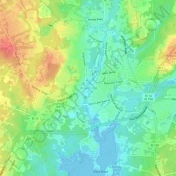
Name: Topografische Karte Wakefield, Höhe, Relief.
Durchschnittliche Höhe: 23 m
Minimale Höhe: -4 m
Maximale Höhe: 59 m
Andere topografische Karten
Klicken Sie auf eine Karte, um ihre Topografie, ihre Höhe und ihr Relief anzuzeigen.
Green Hill Point
United States > Rhode Island > South County > South Kingstown > Green Hill
Green Hill Point, Green Hill, South Kingstown, South County, Rhode Island, United States
Durchschnittliche Höhe: 2 m
Indian Lake
United States > Rhode Island > South County > South Kingstown
Indian Lake, South Kingstown, South County, Rhode Island, United States
Durchschnittliche Höhe: 32 m
Matunuck
United States > Rhode Island > South County > South Kingstown
Matunuck, South Kingstown, South County, Rhode Island, United States
Durchschnittliche Höhe: 5 m