
Topografische Karte Shawnee
Interaktive Karte
Klicken Sie auf die Karte, um die Höhe anzuzeigen.
Über diese Karte
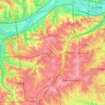
Name: Topografische Karte Shawnee, Höhe, Relief.
Ort: Shawnee, Johnson County, Kansas, United States (38.97092 -94.90890 39.06161 -94.70509)
Durchschnittliche Höhe: 285 m
Minimale Höhe: 219 m
Maximale Höhe: 336 m
Andere topografische Karten
Klicken Sie auf eine Karte, um ihre Topografie, ihre Höhe und ihr Relief anzuzeigen.
Prairie Highlands
United States > Kansas > Johnson County > Olathe
Prairie Highlands, Olathe, Johnson County, Kansas, 66031, United States
Durchschnittliche Höhe: 314 m
Roeland Park
United States > Kansas > Johnson County
Roeland Park, Johnson County, Kansas, 66205, United States
Durchschnittliche Höhe: 291 m
Clearview City
United States > Kansas > Johnson County > De Soto
Clearview City, De Soto, Johnson County, Kansas, 66019, United States
Durchschnittliche Höhe: 273 m
Fairway
United States > Kansas > Johnson County
Fairway, Johnson County, Kansas, United States
Durchschnittliche Höhe: 290 m
Gardner
United States > Kansas > Johnson County
Gardner, Johnson County, Kansas, United States
Durchschnittliche Höhe: 317 m
Overland Park
United States > Kansas > Johnson County
Overland Park, Johnson County, Kansas, United States
Durchschnittliche Höhe: 300 m
Overland Park Arboretum and Botanical Gardens
United States > Kansas > Johnson County > Overland Park
Overland Park Arboretum and Botanical Gardens, Overland Park, Johnson County, Kansas, United States
Durchschnittliche Höhe: 305 m
Holliday
United States > Kansas > Johnson County > Shawnee
Holliday, Shawnee, Johnson County, Kansas, 66218, United States
Durchschnittliche Höhe: 252 m
Spring Hill
United States > Kansas > Johnson County
Spring Hill, Johnson County, Kansas, 66083, United States
Durchschnittliche Höhe: 317 m
Zarah
United States > Kansas > Johnson County > Shawnee
Zarah, Shawnee, Johnson County, Kansas, 66218, United States
Durchschnittliche Höhe: 268 m
Olathe
United States > Kansas > Johnson County
Olathe, Johnson County, Kansas, United States
Durchschnittliche Höhe: 309 m
Prairie Village
United States > Kansas > Johnson County
Prairie Village, Johnson County, Kansas, United States
Durchschnittliche Höhe: 300 m
Leawood
United States > Kansas > Johnson County
Leawood, Johnson County, Kansas, United States
Durchschnittliche Höhe: 289 m
Stilwell
United States > Kansas > Johnson County > Aubry
Stilwell, Aubry, Johnson County, Kansas, 66013, United States
Durchschnittliche Höhe: 326 m
Merriam
United States > Kansas > Johnson County
Merriam, Johnson County, Kansas, United States
Durchschnittliche Höhe: 306 m
De Soto
United States > Kansas > Johnson County
De Soto, Johnson County, Kansas, United States
Durchschnittliche Höhe: 276 m
Leawood
United States > Kansas > Johnson County
Leawood, Johnson County, Kansas, 64114, United States
Durchschnittliche Höhe: 286 m
Overland Park
United States > Kansas > Johnson County > Overland Park
Overland Park, Johnson County, Kansas, 66204, United States
Durchschnittliche Höhe: 288 m
Olathe
United States > Kansas > Johnson County > Olathe
Olathe, Johnson County, Kansas, 6601, United States
Durchschnittliche Höhe: 302 m
Elmhurst
United States > Kansas > Johnson County > Overland Park > Elmhurst
Elmhurst, Overland Park, Johnson County, Kansas, 66204, United States
Durchschnittliche Höhe: 313 m
Mission
United States > Kansas > Johnson County
Mission, Johnson County, Kansas, 66202, United States
Durchschnittliche Höhe: 301 m
Lenexa
United States > Kansas > Johnson County > Lenexa
Lenexa, Johnson County, Kansas, 66219, United States
Durchschnittliche Höhe: 290 m
Lake Quivira
United States > Kansas > Johnson County
Lake Quivira, Johnson County, Kansas, United States
Durchschnittliche Höhe: 269 m
Lenexa
United States > Kansas > Johnson County
Lenexa, Johnson County, Kansas, United States
Durchschnittliche Höhe: 301 m
Mission Hills
United States > Kansas > Johnson County
Mission Hills, Johnson County, Kansas, United States
Durchschnittliche Höhe: 288 m
Edgerton
United States > Kansas > Johnson County > Edgerton
Edgerton, Johnson County, Kansas, United States
Durchschnittliche Höhe: 308 m